Midway Point geodata
Midway Point (Tasmania) is a populated place; located in Australia in Australia/Hobart (GMT+11) time zone. With population of 2,780 people, there are 2389 cities with bigger population in this country. Compared to other cities in Australia, 98.6% of cities are located further ↑North; 50.1% of cities are located further ←West and 50.2% of cities have lower elevation than Midway Point. Note1


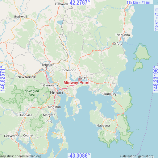
Midway Point GPS coordinates[2]
42° 47' 41.28" South, 147° 31' 43.788" East
| Map corner | latitude | longitude |
|---|---|---|
| Upper-left | -42.2767°, | 146.82571° |
| Center: | -42.7948°, | 147.52883° |
| Lower-right: | -43.3086°, | 148.23196° |
| Map W x H: | 114.7×114.7 km | = 71.3×71.3mi |
| max Lat: | -10.58257° ⇑98.6% North |
| Midway Point: | -42.7948° |
| min Lat: | ⇓1.4% South -43.31423° |
| min Long | Midway Point | max Long |
| 113.53327° | 147.52883° | 153.61246° |
| W 50.1%⇐ | ⇒49.9% E |
Elevation
Elevation of Midway Point is 46 m = 151 ft, and this is 76 m = 249 ft below average elevation for this country.
| Max E: |
1715 m = 5627 ft | 49.8% |
| Avg. | 122 m = 400 ft | |
| Midway Point | 46 m = 151 ft | |
Min E: |
-2 m = -7 ft | 50.2% |
See also: Australia elevation on elevation.city.
Geographical zone
Midway Point is located in South temperate zone (between Tropic of Capricorn and the Antarctic Circle). Distance of this Southern Tropic circle is 2152.4 km =1337.4 mi to North.| Distance of | km | miles | from Midway Point |
|---|---|---|---|
| Equator | 4758.3 | 2956.7 | to North |
| Tropic Capricorn | 2152.4 | 1337.4 | to North |
| Antarctic Circle | 2642.8 | 1642.2 | to South |
| South Pole | 5248.7 | 3261.4 | to South |


Nearby cities:
15 places around Midway Point: (largest is in red/bold)
• Acton Park
10.1 km =6.3 mi,  200°
200°
• Cambridge
7.7 km =4.8 mi,  236°
236°
• Carlton
12.7 km =7.9 mi,  125°
125°
• Clarendon Vale
12.6 km =7.8 mi,  213°
213°
• Dodges Ferry
10 km =6.2 mi, 130°
• Forcett
8.5 km =5.3 mi,  93°
93°
• Lauderdale
13.6 km =8.5 mi,  194°
194°
• Lewisham
8.3 km =5.2 mi,  120°
120°
• Mornington
13.1 km =8.1 mi,  234°
234°
• Oakdowns
13.3 km =8.3 mi, 206°
• Richmond
9.9 km =6.2 mi,  311°
311°
• Rokeby
13.3 km =8.3 mi, 209°
• Seven Mile Beach
7.4 km =4.6 mi, 195°
• Sorell
3.1 km =1.9 mi,  62°
62°
• Warrane
13.7 km =8.5 mi, 240°
Sources, notices
• [Note1] Compared only with cities in Australia existing in our database
• [Src1] Map data: © OpenStreetMap contributors (CC-BY-SA)
• [Src2] Other city data from geonames.org with taken over terms of usage.
• [Src3] Geographical zone / Annual Mean Temperature by Robert A. Rohde @ Wikipedia
