Wollongong geodata
Wollongong (New South Wales) is a seat of a second-order administrative division; located in Australia in Australia/Sydney (GMT+11) time zone. With population of 292,190 people, there are 8 cities with bigger population in this country. Compared to other cities in Australia, 62.6% of cities are located further ↑North; 65.4% of cities are located further ←West and 99.9% of cities have higher elevation than Wollongong. Note1


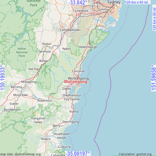
Wollongong GPS coordinates[2]
34° 25' 26.4" South, 150° 53' 36.42" East
| Map corner | latitude | longitude |
|---|---|---|
| Upper-left | -33.842°, | 150.19033° |
| Center: | -34.424°, | 150.89345° |
| Lower-right: | -35.00197°, | 151.59658° |
| Map W x H: | 129×129 km | = 80.2×80.2mi |
| max Lat: | -10.58257° ⇑62.6% North |
| Wollongong: | -34.424° |
| min Lat: | ⇓37.4% South -43.31423° |
| min Long | Wollongong | max Long |
| 113.53327° | 150.89345° | 153.61246° |
| W 65.4%⇐ | ⇒34.6% E |
Elevation
Elevation of Wollongong is 1 m = 3 ft, and this is 121 m = 397 ft below average elevation for this country.
| Max E: |
1715 m = 5627 ft | 99.9% |
| Avg. | 122 m = 400 ft | |
| Wollongong | 1 m = 3 ft | |
Min E: |
-2 m = -7 ft | 0.1% |
See also: Wollongong elevation on elevation.city.
Geographical zone
Wollongong is located in South temperate zone (between Tropic of Capricorn and the Antarctic Circle). Distance of this Southern Tropic circle is 1221.7 km =759.1 mi to North.| Distance of | km | miles | from Wollongong |
|---|---|---|---|
| Equator | 3827.6 | 2378.4 | to North |
| Tropic Capricorn | 1221.7 | 759.1 | to North |
| Antarctic Circle | 3573.6 | 2220.5 | to South |
| South Pole | 6179.5 | 3839.8 | to South |


Nearby cities:
15 places around Wollongong: (largest is in red/bold)
• Balgownie
3.4 km =2.1 mi,  339°
339°
• Coniston
3 km =1.9 mi,  197°
197°
• Fairy Meadow
3.4 km =2.1 mi,  358°
358°
• Fern Hill
4.6 km =2.9 mi,  351°
351°
• Figtree
3.5 km =2.2 mi,  248°
248°
• Gwynneville
1 km =0.6 mi,  326°
326°
• Keiraville
2.6 km =1.6 mi,  288°
288°
• Mangerton
2.4 km =1.5 mi,  234°
234°
• Mount Ousley
2.5 km =1.6 mi, 348°
• Mount Pleasant
4 km =2.5 mi,  322°
322°
• Mount Saint Thomas
2.9 km =1.8 mi,  222°
222°
• North Wollongong
2.1 km =1.3 mi,  10°
10°
• Towradgi
4.2 km =2.6 mi, 11°
• West Wollongong
2.7 km =1.7 mi,  268°
268°
• Wollongong city centre
0.4 km =0.2 mi,  189°
189°
Sources, notices
• [Note1] Compared only with cities in Australia existing in our database
• [Src1] Map data: © OpenStreetMap contributors (CC-BY-SA)
• [Src2] Other city data from geonames.org with taken over terms of usage.
• [Src3] Geographical zone / Annual Mean Temperature by Robert A. Rohde @ Wikipedia
