Junee geodata
Junee (New South Wales) is a populated place; located in Australia in Australia/Sydney (GMT+11) time zone. With population of 4,833 people, there are 1525 cities with bigger population in this country. Compared to other cities in Australia, 67.2% of cities are located further ↑North; 50.2% of cities are located further ←West and 87.5% of cities have lower elevation than Junee. Note1


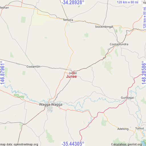
Junee GPS coordinates[2]
34° 52' 5.484" South, 147° 34' 57.828" East
| Map corner | latitude | longitude |
|---|---|---|
| Upper-left | -34.28928°, | 146.87961° |
| Center: | -34.86819°, | 147.58273° |
| Lower-right: | -35.44305°, | 148.28586° |
| Map W x H: | 128.3×128.3 km | = 79.7×79.7mi |
| max Lat: | -10.58257° ⇑67.2% North |
| Junee: | -34.86819° |
| min Lat: | ⇓32.8% South -43.31423° |
| min Long | Junee | max Long |
| 113.53327° | 147.58273° | 153.61246° |
| W 50.2%⇐ | ⇒49.8% E |
Elevation
Elevation of Junee is 301 m = 988 ft, and this is 179 m = 587 ft above average elevation for this country.
| Max E: |
1715 m = 5627 ft | 12.5% |
| Junee | 301 m 988 ft | |
| Avg. | 122 m = 400 ft | |
Min E: |
-2 m = -7 ft | 87.5% |
See also: Australia elevation on elevation.city.
Geographical zone
Junee is located in South temperate zone (between Tropic of Capricorn and the Antarctic Circle). Distance of this Southern Tropic circle is 1271.1 km =789.8 mi to North.| Distance of | km | miles | from Junee |
|---|---|---|---|
| Equator | 3877 | 2409.1 | to North |
| Tropic Capricorn | 1271.1 | 789.8 | to North |
| Antarctic Circle | 3524.2 | 2189.8 | to South |
| South Pole | 6130.1 | 3809.1 | to South |


Nearby cities:
15 places around Junee: (largest is in red/bold)
• Ashmont
36.6 km =22.7 mi,  218°
218°
• Boorooma
30.3 km =18.8 mi, 220°
• Bourkelands
38.5 km =23.9 mi,  213°
213°
• Charles Sturt University
29.9 km =18.6 mi, 224°
• Coolamon
35.8 km =22.2 mi,  279°
279°
• Estella
30.6 km =19 mi, 222°
• Forest Hill
32.9 km =20.4 mi,  198°
198°
• Glenfield Park
37.6 km =23.4 mi, 217°
• Kooringal
35.6 km =22.1 mi, 211°
• Lake Albert
37.8 km =23.5 mi, 208°
• Mount Austin
36.5 km =22.7 mi, 215°
• Tatton
38.3 km =23.8 mi, 212°
• Tolland
37.3 km =23.2 mi, 214°
• Turvey Park
35.2 km =21.9 mi, 214°
• Wagga Wagga
35.4 km =22 mi, 216°
Sources, notices
• [Note1] Compared only with cities in Australia existing in our database
• [Src1] Map data: © OpenStreetMap contributors (CC-BY-SA)
• [Src2] Other city data from geonames.org with taken over terms of usage.
• [Src3] Geographical zone / Annual Mean Temperature by Robert A. Rohde @ Wikipedia
