Inglewood geodata
Inglewood (Victoria) is a populated place; located in Australia in Australia/Melbourne (GMT+11) time zone. With population of 854 people, there are 4055 cities with bigger population in this country. Compared to other cities in Australia, 80.1% of cities are located further ↑North; 72.8% of cities are located further →East and 77.4% of cities have lower elevation than Inglewood. Note1


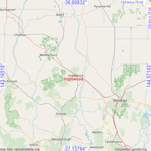
Inglewood GPS coordinates[2]
36° 34' 30.144" South, 143° 52' 5.88" East
| Map corner | latitude | longitude |
|---|---|---|
| Upper-left | -36.00832°, | 143.16518° |
| Center: | -36.57504°, | 143.8683° |
| Lower-right: | -37.13764°, | 144.57143° |
| Map W x H: | 125.6×125.6 km | = 78×78mi |
| max Lat: | -10.58257° ⇑80.1% North |
| Inglewood: | -36.57504° |
| min Lat: | ⇓19.9% South -43.31423° |
| min Long | Inglewood | max Long |
| 113.53327° | 143.8683° | 153.61246° |
| W 27.2%⇐ | ⇒72.8% E |
Elevation
Elevation of Inglewood is 150 m = 492 ft, and this is 28 m = 92 ft above average elevation for this country.
| Max E: |
1715 m = 5627 ft | 22.6% |
| Inglewood | 150 m 492 ft | |
| Avg. | 122 m = 400 ft | |
Min E: |
-2 m = -7 ft | 77.4% |
See also: Australia elevation on elevation.city.
Geographical zone
Inglewood is located in South temperate zone (between Tropic of Capricorn and the Antarctic Circle). Distance of this Southern Tropic circle is 1460.8 km =907.7 mi to North.| Distance of | km | miles | from Inglewood |
|---|---|---|---|
| Equator | 4066.8 | 2527 | to North |
| Tropic Capricorn | 1460.8 | 907.7 | to North |
| Antarctic Circle | 3334.4 | 2071.9 | to South |
| South Pole | 5940.3 | 3691.1 | to South |


Nearby cities:
15 places around Inglewood: (largest is in red/bold)
• Bendigo city centre
41.9 km =26 mi,  118°
118°
• California Gully
39 km =24.2 mi, 116°
• Dunolly
33.9 km =21.1 mi,  200°
200°
• Eaglehawk
37.5 km =23.3 mi,  114°
114°
• Golden Square
40.7 km =25.3 mi, 122°
• Ironbark
40.5 km =25.2 mi, 119°
• Jackass Flat
40.4 km =25.1 mi, 112°
• Lockwood
36.8 km =22.9 mi,  135°
135°
• Lockwood South
39.5 km =24.5 mi, 139°
• Long Gully
39.5 km =24.5 mi, 118°
• Maiden Gully
36.2 km =22.5 mi, 123°
• Marong
29.5 km =18.3 mi,  126°
126°
• North Bendigo
41.9 km =26 mi, 116°
• Sailors Gully
36.1 km =22.4 mi, 114°
• Wedderburn
28.6 km =17.8 mi,  307°
307°
Sources, notices
• [Note1] Compared only with cities in Australia existing in our database
• [Src1] Map data: © OpenStreetMap contributors (CC-BY-SA)
• [Src2] Other city data from geonames.org with taken over terms of usage.
• [Src3] Geographical zone / Annual Mean Temperature by Robert A. Rohde @ Wikipedia
