Wedderburn geodata
Wedderburn (Victoria) is a populated place; located in Australia in Australia/Melbourne (GMT+11) time zone. With population of 916 people, there are 3954 cities with bigger population in this country. Compared to other cities in Australia, 79.8% of cities are located further ↑North; 73.6% of cities are located further →East and 80.7% of cities have lower elevation than Wedderburn. Note1


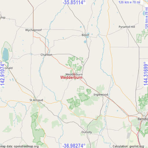
Wedderburn GPS coordinates[2]
36° 25' 8.4" South, 143° 36' 49.896" East
| Map corner | latitude | longitude |
|---|---|---|
| Upper-left | -35.85114°, | 142.91074° |
| Center: | -36.419°, | 143.61386° |
| Lower-right: | -36.98274°, | 144.31699° |
| Map W x H: | 125.8×125.8 km | = 78.2×78.2mi |
| max Lat: | -10.58257° ⇑79.8% North |
| Wedderburn: | -36.419° |
| min Lat: | ⇓20.2% South -43.31423° |
| min Long | Wedderburn | max Long |
| 113.53327° | 143.61386° | 153.61246° |
| W 26.4%⇐ | ⇒73.6% E |
Elevation
Elevation of Wedderburn is 189 m = 620 ft, and this is 67 m = 220 ft above average elevation for this country.
| Max E: |
1715 m = 5627 ft | 19.3% |
| Wedderburn | 189 m 620 ft | |
| Avg. | 122 m = 400 ft | |
Min E: |
-2 m = -7 ft | 80.7% |
See also: Australia elevation on elevation.city.
Geographical zone
Wedderburn is located in South temperate zone (between Tropic of Capricorn and the Antarctic Circle). Distance of this Southern Tropic circle is 1443.5 km =896.9 mi to North.| Distance of | km | miles | from Wedderburn |
|---|---|---|---|
| Equator | 4049.4 | 2516.2 | to North |
| Tropic Capricorn | 1443.5 | 896.9 | to North |
| Antarctic Circle | 3351.8 | 2082.7 | to South |
| South Pole | 5957.6 | 3701.9 | to South |


Nearby cities:
15 places around Wedderburn: (largest is in red/bold)
• Boort
35 km =21.7 mi,  15°
15°
• California Gully
67.3 km =41.8 mi,  120°
120°
• Charlton
29.3 km =18.2 mi,  305°
305°
• Donald
56.9 km =35.4 mi,  275°
275°
• Dunolly
50.2 km =31.2 mi,  167°
167°
• Eaglehawk
65.8 km =40.9 mi, 120°
• Inglewood
28.6 km =17.8 mi,  127°
127°
• Lockwood
65.2 km =40.5 mi, 131°
• Lockwood South
67.8 km =42.1 mi, 134°
• Long Gully
67.9 km =42.2 mi, 122°
• Maiden Gully
64.8 km =40.3 mi, 125°
• Marong
58.1 km =36.1 mi, 126°
• Pyramid Hill
60.4 km =37.5 mi,  48°
48°
• Sailors Gully
64.3 km =40 mi, 120°
• Wycheproof
51.4 km =31.9 mi,  317°
317°
Sources, notices
• [Note1] Compared only with cities in Australia existing in our database
• [Src1] Map data: © OpenStreetMap contributors (CC-BY-SA)
• [Src2] Other city data from geonames.org with taken over terms of usage.
• [Src3] Geographical zone / Annual Mean Temperature by Robert A. Rohde @ Wikipedia
