Hawks Nest geodata
Hawks Nest (New South Wales) is a populated place; located in Australia in Australia/Sydney (GMT+11) time zone. With population of 1,299 people, there are 3478 cities with bigger population in this country. Compared to other cities in Australia, 60.8% of cities are located further ↓South; 83.2% of cities are located further ←West and 83.5% of cities have higher elevation than Hawks Nest. Note1


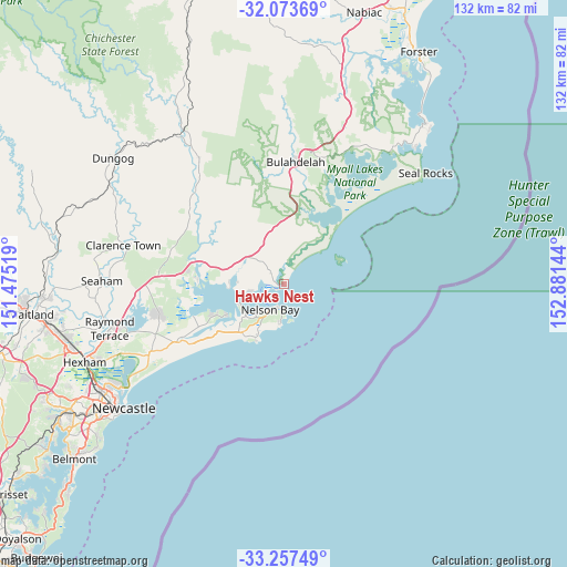
Hawks Nest GPS coordinates[2]
32° 40' 3.18" South, 152° 10' 41.916" East
| Map corner | latitude | longitude |
|---|---|---|
| Upper-left | -32.07369°, | 151.47519° |
| Center: | -32.66755°, | 152.17831° |
| Lower-right: | -33.25749°, | 152.88144° |
| Map W x H: | 131.6×131.6 km | = 81.8×81.8mi |
| max Lat: | -10.58257° ⇑39.2% North |
| Hawks Nest: | -32.66755° |
| min Lat: | ⇓60.8% South -43.31423° |
| min Long | Hawks Nest | max Long |
| 113.53327° | 152.17831° | 153.61246° |
| W 83.2%⇐ | ⇒16.8% E |
Elevation
Elevation of Hawks Nest is 13 m = 43 ft, and this is 109 m = 358 ft below average elevation for this country.
| Max E: |
1715 m = 5627 ft | 83.5% |
| Avg. | 122 m = 400 ft | |
| Hawks Nest | 13 m = 43 ft | |
Min E: |
-2 m = -7 ft | 16.5% |
See also: Australia elevation on elevation.city.
Geographical zone
Hawks Nest is located in South temperate zone (between Tropic of Capricorn and the Antarctic Circle). Distance of this Southern Tropic circle is 1026.4 km =637.8 mi to North.| Distance of | km | miles | from Hawks Nest |
|---|---|---|---|
| Equator | 3632.3 | 2257 | to North |
| Tropic Capricorn | 1026.4 | 637.8 | to North |
| Antarctic Circle | 3768.9 | 2341.9 | to South |
| South Pole | 6374.8 | 3961.1 | to South |


Nearby cities:
15 places around Hawks Nest: (largest is in red/bold)
• Anna Bay
15.3 km =9.5 mi,  214°
214°
• Boat Harbour
15 km =9.3 mi, 205°
• Bulahdelah
29.1 km =18.1 mi,  6°
6°
• Corlette
8.8 km =5.5 mi,  228°
228°
• Fingal Bay
9.2 km =5.7 mi,  184°
184°
• Karuah
20.5 km =12.7 mi,  274°
274°
• Lemon Tree Passage
14.8 km =9.2 mi,  241°
241°
• Mallabula
16.9 km =10.5 mi,  246°
246°
• Nelson Bay
6.7 km =4.2 mi, 208°
• Salamander Bay
11.1 km =6.9 mi, 236°
• Salt Ash
27.7 km =17.2 mi, 242°
• Shoal Bay
6.1 km =3.8 mi, 182°
• Soldiers Point
11.2 km =7 mi, 244°
• Tanilba Bay
19.1 km =11.9 mi, 242°
• Tea Gardens
2.3 km =1.4 mi,  281°
281°
Sources, notices
• [Note1] Compared only with cities in Australia existing in our database
• [Src1] Map data: © OpenStreetMap contributors (CC-BY-SA)
• [Src2] Other city data from geonames.org with taken over terms of usage.
• [Src3] Geographical zone / Annual Mean Temperature by Robert A. Rohde @ Wikipedia
