Karuah geodata
Karuah (New South Wales) is a section of populated place; located in Australia in Australia/Sydney (GMT+11) time zone. With population of 1,397 people, there are 3373 cities with bigger population in this country. Compared to other cities in Australia, 60.9% of cities are located further ↓South; 82.3% of cities are located further ←West and 77.5% of cities have higher elevation than Karuah. Note1


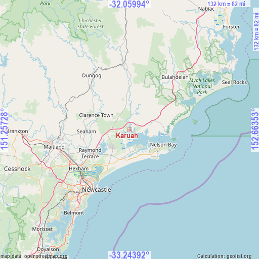
Karuah GPS coordinates[2]
32° 39' 14.004" South, 151° 57' 37.44" East
| Map corner | latitude | longitude |
|---|---|---|
| Upper-left | -32.05994°, | 151.25728° |
| Center: | -32.65389°, | 151.9604° |
| Lower-right: | -33.24392°, | 152.66353° |
| Map W x H: | 131.6×131.6 km | = 81.8×81.8mi |
| max Lat: | -10.58257° ⇑39.1% North |
| Karuah: | -32.65389° |
| min Lat: | ⇓60.9% South -43.31423° |
| min Long | Karuah | max Long |
| 113.53327° | 151.9604° | 153.61246° |
| W 82.3%⇐ | ⇒17.7% E |
Elevation
Elevation of Karuah is 17 m = 56 ft, and this is 105 m = 344 ft below average elevation for this country.
| Max E: |
1715 m = 5627 ft | 77.5% |
| Avg. | 122 m = 400 ft | |
| Karuah | 17 m = 56 ft | |
Min E: |
-2 m = -7 ft | 22.5% |
See also: Australia elevation on elevation.city.
Geographical zone
Karuah is located in South temperate zone (between Tropic of Capricorn and the Antarctic Circle). Distance of this Southern Tropic circle is 1024.9 km =636.8 mi to North.| Distance of | km | miles | from Karuah |
|---|---|---|---|
| Equator | 3630.8 | 2256.1 | to North |
| Tropic Capricorn | 1024.9 | 636.8 | to North |
| Antarctic Circle | 3770.4 | 2342.8 | to South |
| South Pole | 6376.3 | 3962 | to South |


Nearby cities:
15 places around Karuah: (largest is in red/bold)
• Anna Bay
18.4 km =11.4 mi,  140°
140°
• Boat Harbour
20.5 km =12.7 mi, 137°
• Clarence Town
18.8 km =11.7 mi,  294°
294°
• Corlette
15.7 km =9.8 mi,  117°
117°
• Hawks Nest
20.5 km =12.7 mi,  94°
94°
• Lemon Tree Passage
11.2 km =7 mi, 139°
• Mallabula
9.6 km =6 mi,  149°
149°
• Medowie
13 km =8.1 mi,  221°
221°
• Nelson Bay
18.7 km =11.6 mi,  113°
113°
• Salamander Bay
13.5 km =8.4 mi, 124°
• Salt Ash
15 km =9.3 mi,  195°
195°
• Soldiers Point
12 km =7.5 mi, 121°
• Tanilba Bay
10.9 km =6.8 mi,  161°
161°
• Tea Gardens
18.2 km =11.3 mi, 93°
• Williamtown
20.2 km =12.6 mi,  212°
212°
Sources, notices
• [Note1] Compared only with cities in Australia existing in our database
• [Src1] Map data: © OpenStreetMap contributors (CC-BY-SA)
• [Src2] Other city data from geonames.org with taken over terms of usage.
• [Src3] Geographical zone / Annual Mean Temperature by Robert A. Rohde @ Wikipedia
