Bulahdelah geodata
Bulahdelah (New South Wales) is a populated place; located in Australia in Australia/Sydney (GMT+11) time zone. With population of 1,480 people, there are 3295 cities with bigger population in this country. Compared to other cities in Australia, 61.8% of cities are located further ↓South; 83.3% of cities are located further ←West and 83.5% of cities have higher elevation than Bulahdelah. Note1


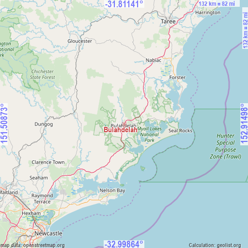
Bulahdelah GPS coordinates[2]
32° 24' 25.128" South, 152° 12' 42.66" East
| Map corner | latitude | longitude |
|---|---|---|
| Upper-left | -31.81141°, | 151.50873° |
| Center: | -32.40698°, | 152.21185° |
| Lower-right: | -32.99864°, | 152.91498° |
| Map W x H: | 132×132 km | = 82×82mi |
| max Lat: | -10.58257° ⇑38.2% North |
| Bulahdelah: | -32.40698° |
| min Lat: | ⇓61.8% South -43.31423° |
| min Long | Bulahdelah | max Long |
| 113.53327° | 152.21185° | 153.61246° |
| W 83.3%⇐ | ⇒16.7% E |
Elevation
Elevation of Bulahdelah is 13 m = 43 ft, and this is 109 m = 358 ft below average elevation for this country.
| Max E: |
1715 m = 5627 ft | 83.5% |
| Avg. | 122 m = 400 ft | |
| Bulahdelah | 13 m = 43 ft | |
Min E: |
-2 m = -7 ft | 16.5% |
See also: Australia elevation on elevation.city.
Geographical zone
Bulahdelah is located in South temperate zone (between Tropic of Capricorn and the Antarctic Circle). Distance of this Southern Tropic circle is 997.4 km =619.8 mi to North.| Distance of | km | miles | from Bulahdelah |
|---|---|---|---|
| Equator | 3603.3 | 2239 | to North |
| Tropic Capricorn | 997.4 | 619.8 | to North |
| Antarctic Circle | 3797.9 | 2359.9 | to South |
| South Pole | 6403.7 | 3979.1 | to South |


Nearby cities:
15 places around Bulahdelah: (largest is in red/bold)
• Coomba Park
29.8 km =18.5 mi,  50°
50°
• Corlette
36.1 km =22.4 mi,  195°
195°
• Forster
38.1 km =23.7 mi, 48°
• Green Point
33.7 km =20.9 mi,  58°
58°
• Hawks Nest
29.1 km =18.1 mi,  186°
186°
• Karuah
36.2 km =22.5 mi,  220°
220°
• Nabiac
37.6 km =23.4 mi,  24°
24°
• Nelson Bay
35.4 km =22 mi, 190°
• Salamander Bay
37.2 km =23.1 mi, 199°
• Shoal Bay
35.2 km =21.9 mi, 185°
• Smiths Lake
27.5 km =17.1 mi,  83°
83°
• Soldiers Point
36.3 km =22.6 mi, 201°
• Stroud
23 km =14.3 mi,  270°
270°
• Tea Gardens
29 km =18 mi, 190°
• Tuncurry
37.4 km =23.2 mi, 46°
Sources, notices
• [Note1] Compared only with cities in Australia existing in our database
• [Src1] Map data: © OpenStreetMap contributors (CC-BY-SA)
• [Src2] Other city data from geonames.org with taken over terms of usage.
• [Src3] Geographical zone / Annual Mean Temperature by Robert A. Rohde @ Wikipedia
