Hallam geodata
Hallam (Victoria) is a section of populated place; located in Australia in Australia/Melbourne (GMT+11) time zone. With population of 10,776 people, there are 510 cities with bigger population in this country. Compared to other cities in Australia, 91.9% of cities are located further ↑North; 61.9% of cities are located further →East and 69.8% of cities have higher elevation than Hallam. Note1


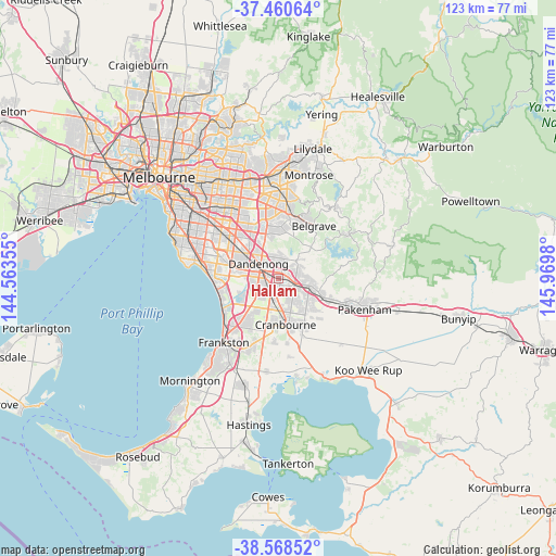
Hallam GPS coordinates[2]
38° 1' 0.012" South, 145° 16' 0.012" East
| Map corner | latitude | longitude |
|---|---|---|
| Upper-left | -37.46064°, | 144.56355° |
| Center: | -38.01667°, | 145.26667° |
| Lower-right: | -38.56852°, | 145.9698° |
| Map W x H: | 123.2×123.2 km | = 76.6×76.6mi |
| max Lat: | -10.58257° ⇑91.9% North |
| Hallam: | -38.01667° |
| min Lat: | ⇓8.1% South -43.31423° |
| min Long | Hallam | max Long |
| 113.53327° | 145.26667° | 153.61246° |
| W 38.1%⇐ | ⇒61.9% E |
Elevation
Elevation of Hallam is 23 m = 75 ft, and this is 99 m = 325 ft below average elevation for this country.
| Max E: |
1715 m = 5627 ft | 69.8% |
| Avg. | 122 m = 400 ft | |
| Hallam | 23 m = 75 ft | |
Min E: |
-2 m = -7 ft | 30.2% |
See also: Australia elevation on elevation.city.
Geographical zone
Hallam is located in South temperate zone (between Tropic of Capricorn and the Antarctic Circle). Distance of this Southern Tropic circle is 1621.1 km =1007.3 mi to North.| Distance of | km | miles | from Hallam |
|---|---|---|---|
| Equator | 4227.1 | 2626.6 | to North |
| Tropic Capricorn | 1621.1 | 1007.3 | to North |
| Antarctic Circle | 3174.1 | 1972.3 | to South |
| South Pole | 5780 | 3591.5 | to South |


Nearby cities:
15 places around Hallam: (largest is in red/bold)
• Bangholme
7.4 km =4.6 mi,  250°
250°
• Berwick
7.5 km =4.7 mi,  104°
104°
• Cranbourne North
7.3 km =4.5 mi,  157°
157°
• Dandenong
6.9 km =4.3 mi,  302°
302°
• Dandenong North
7.6 km =4.7 mi,  317°
317°
• Doveton
3.5 km =2.2 mi, 316°
• Endeavour Hills
4.5 km =2.8 mi,  350°
350°
• Eumemmerring
2.6 km =1.6 mi, 322°
• Hampton Park
2.4 km =1.5 mi,  218°
218°
• Harkaway
7.5 km =4.7 mi,  75°
75°
• Lynbrook
4.5 km =2.8 mi,  191°
191°
• Lysterfield South
6.5 km =4 mi,  4°
4°
• Narre Warren
3.5 km =2.2 mi,  122°
122°
• Narre Warren North
5.7 km =3.5 mi,  49°
49°
• Narre Warren South
3.8 km =2.4 mi,  143°
143°
Sources, notices
• [Note1] Compared only with cities in Australia existing in our database
• [Src1] Map data: © OpenStreetMap contributors (CC-BY-SA)
• [Src2] Other city data from geonames.org with taken over terms of usage.
• [Src3] Geographical zone / Annual Mean Temperature by Robert A. Rohde @ Wikipedia
