Cranbourne North geodata
Cranbourne North (Victoria) is a section of populated place; located in Australia in Australia/Melbourne (GMT+11) time zone. With population of 19,900 people, there are 170 cities with bigger population in this country. Compared to other cities in Australia, 92.4% of cities are located further ↑North; 61.5% of cities are located further →East and 53.1% of cities have higher elevation than Cranbourne North. Note1


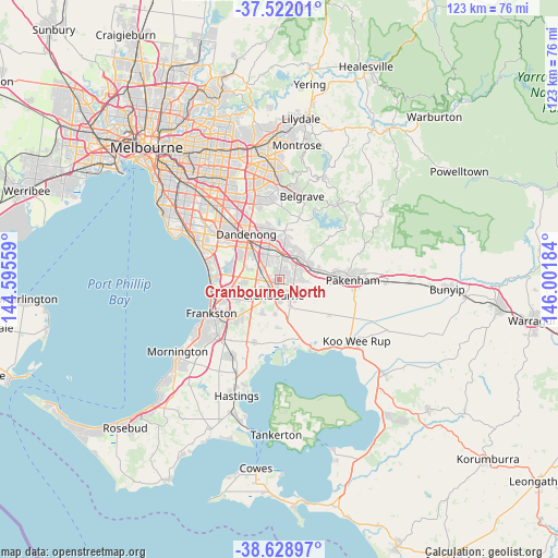
Cranbourne North GPS coordinates[2]
38° 4' 39.288" South, 145° 17' 55.356" East
| Map corner | latitude | longitude |
|---|---|---|
| Upper-left | -37.52201°, | 144.59559° |
| Center: | -38.07758°, | 145.29871° |
| Lower-right: | -38.62897°, | 146.00184° |
| Map W x H: | 123.1×123.1 km | = 76.5×76.5mi |
| max Lat: | -10.58257° ⇑92.4% North |
| Cranbourne North: | -38.07758° |
| min Lat: | ⇓7.6% South -43.31423° |
| min Long | Cranbourne Nort | max Long |
| 113.53327° | 145.29871° | 153.61246° |
| W 38.5%⇐ | ⇒61.5% E |
Elevation
Elevation of Cranbourne North is 41 m = 135 ft, and this is 81 m = 266 ft below average elevation for this country.
| Max E: |
1715 m = 5627 ft | 53.1% |
| Avg. | 122 m = 400 ft | |
| Cranbourne North | 41 m = 135 ft | |
Min E: |
-2 m = -7 ft | 46.9% |
See also: Australia elevation on elevation.city.
Geographical zone
Cranbourne North is located in South temperate zone (between Tropic of Capricorn and the Antarctic Circle). Distance of this Southern Tropic circle is 1627.9 km =1011.5 mi to North.| Distance of | km | miles | from Cranbourne North |
|---|---|---|---|
| Equator | 4233.8 | 2630.8 | to North |
| Tropic Capricorn | 1627.9 | 1011.5 | to North |
| Antarctic Circle | 3167.3 | 1968.1 | to South |
| South Pole | 5773.2 | 3587.3 | to South |


Nearby cities:
15 places around Cranbourne North: (largest is in red/bold)
• Beaconsfield
6.7 km =4.2 mi,  62°
62°
• Berwick
6.7 km =4.2 mi,  42°
42°
• Botanic Ridge
7.3 km =4.5 mi,  201°
201°
• Clyde
6.9 km =4.3 mi,  153°
153°
• Clyde North
5.3 km =3.3 mi, 145°
• Cranbourne
4.2 km =2.6 mi, 198°
• Cranbourne East
4.2 km =2.6 mi,  180°
180°
• Cranbourne West
3.5 km =2.2 mi,  232°
232°
• Hallam
7.3 km =4.5 mi,  337°
337°
• Hampton Park
6.5 km =4 mi,  319°
319°
• Junction Village
6.5 km =4 mi, 181°
• Lynbrook
4.4 km =2.7 mi,  302°
302°
• Narre Warren
4.9 km =3 mi,  1°
1°
• Narre Warren South
3.8 km =2.4 mi,  351°
351°
• Skye
7.8 km =4.8 mi,  247°
247°
Sources, notices
• [Note1] Compared only with cities in Australia existing in our database
• [Src1] Map data: © OpenStreetMap contributors (CC-BY-SA)
• [Src2] Other city data from geonames.org with taken over terms of usage.
• [Src3] Geographical zone / Annual Mean Temperature by Robert A. Rohde @ Wikipedia
