Habana geodata
Habana (Queensland) is a populated place; located in Australia in Australia/Brisbane (GMT+10) time zone. With population of 925 people, there are 3938 cities with bigger population in this country. Compared to other cities in Australia, 93.6% of cities are located further ↓South; 53.6% of cities are located further ←West and 63.7% of cities have higher elevation than Habana. Note1


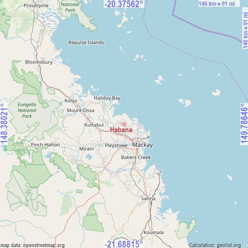
Habana GPS coordinates[2]
21° 1' 59.988" South, 149° 4' 59.988" East
| Map corner | latitude | longitude |
|---|---|---|
| Upper-left | -20.37562°, | 148.38021° |
| Center: | -21.03333°, | 149.08333° |
| Lower-right: | -21.68815°, | 149.78646° |
| Map W x H: | 145.9×145.9 km | = 90.7×90.7mi |
| max Lat: | -10.58257° ⇑6.4% North |
| Habana: | -21.03333° |
| min Lat: | ⇓93.6% South -43.31423° |
| min Long | Habana | max Long |
| 113.53327° | 149.08333° | 153.61246° |
| W 53.6%⇐ | ⇒46.4% E |
Elevation
Elevation of Habana is 28 m = 92 ft, and this is 94 m = 308 ft below average elevation for this country.
| Max E: |
1715 m = 5627 ft | 63.7% |
| Avg. | 122 m = 400 ft | |
| Habana | 28 m = 92 ft | |
Min E: |
-2 m = -7 ft | 36.3% |
See also: Australia elevation on elevation.city.
Geographical zone
Habana is located in South Torrid zone (between Equator and Tropic of Capricorn). Distance of this Southern Tropic circle is 267.2 km =166 mi to South.| Distance of | km | miles | from Habana |
|---|---|---|---|
| Equator | 2338.7 | 1453.2 | to North |
| Tropic Capricorn | 267.2 | 166 | to South |
| Antarctic Circle | 5062.5 | 3145.7 | to South |
| South Pole | 7668.4 | 4764.9 | to South |


Nearby cities:
15 places around Habana: (largest is in red/bold)
• Andergrove
11.8 km =7.3 mi,  118°
118°
• Beaconsfield
10.7 km =6.6 mi,  127°
127°
• Blacks Beach
11.3 km =7 mi,  102°
102°
• Bucasia
7.7 km =4.8 mi,  91°
91°
• Eimeo
9.7 km =6 mi, 92°
• Erakala
11.1 km =6.9 mi,  161°
161°
• Farleigh
8.3 km =5.2 mi,  166°
166°
• Glenella
11.3 km =7 mi,  145°
145°
• Mount Pleasant
12.3 km =7.6 mi,  139°
139°
• North Mackay
13.9 km =8.6 mi, 134°
• Rural View
9.1 km =5.7 mi,  112°
112°
• Shoal Point
7.9 km =4.9 mi,  66°
66°
• Slade Point
15.4 km =9.6 mi, 107°
• The Leap
8.9 km =5.5 mi,  231°
231°
• Walkerston
14.4 km =8.9 mi,  190°
190°
Sources, notices
• [Note1] Compared only with cities in Australia existing in our database
• [Src1] Map data: © OpenStreetMap contributors (CC-BY-SA)
• [Src2] Other city data from geonames.org with taken over terms of usage.
• [Src3] Geographical zone / Annual Mean Temperature by Robert A. Rohde @ Wikipedia
