Andergrove geodata
Andergrove (Queensland) is a section of populated place; located in Australia in Australia/Brisbane (GMT+10) time zone. With population of 9,097 people, there are 691 cities with bigger population in this country. Compared to other cities in Australia, 93.4% of cities are located further ↓South; 55.3% of cities are located further ←West and 90.1% of cities have higher elevation than Andergrove. Note1


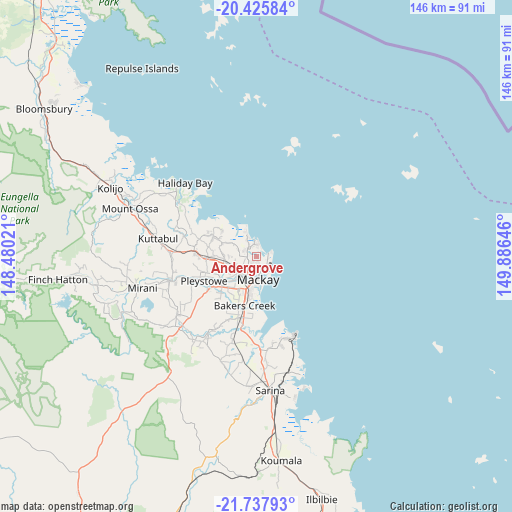
Andergrove GPS coordinates[2]
21° 4' 59.988" South, 149° 10' 59.988" East
| Map corner | latitude | longitude |
|---|---|---|
| Upper-left | -20.42584°, | 148.48021° |
| Center: | -21.08333°, | 149.18333° |
| Lower-right: | -21.73793°, | 149.88646° |
| Map W x H: | 145.9×145.9 km | = 90.7×90.7mi |
| max Lat: | -10.58257° ⇑6.6% North |
| Andergrove: | -21.08333° |
| min Lat: | ⇓93.4% South -43.31423° |
| min Long | Andergrove | max Long |
| 113.53327° | 149.18333° | 153.61246° |
| W 55.3%⇐ | ⇒44.7% E |
Elevation
Elevation of Andergrove is 9 m = 30 ft, and this is 113 m = 371 ft below average elevation for this country.
| Max E: |
1715 m = 5627 ft | 90.1% |
| Avg. | 122 m = 400 ft | |
| Andergrove | 9 m = 30 ft | |
Min E: |
-2 m = -7 ft | 9.9% |
See also: Australia elevation on elevation.city.
Geographical zone
Andergrove is located in South Torrid zone (between Equator and Tropic of Capricorn). Distance of this Southern Tropic circle is 261.7 km =162.6 mi to South.| Distance of | km | miles | from Andergrove |
|---|---|---|---|
| Equator | 2344.2 | 1456.6 | to North |
| Tropic Capricorn | 261.7 | 162.6 | to South |
| Antarctic Circle | 5056.9 | 3142.2 | to South |
| South Pole | 7662.8 | 4761.4 | to South |


Nearby cities:
15 places around Andergrove: (largest is in red/bold)
• Beaconsfield
2.1 km =1.3 mi,  244°
244°
• Blacks Beach
3.3 km =2.1 mi,  11°
11°
• Bucasia
6 km =3.7 mi,  333°
333°
• East Mackay
7.5 km =4.7 mi,  169°
169°
• Eimeo
5.1 km =3.2 mi,  351°
351°
• Erakala
8.5 km =5.3 mi,  234°
234°
• Glenella
5.5 km =3.4 mi, 226°
• Mackay
8 km =5 mi,  193°
193°
• Mackay City
6.8 km =4.2 mi,  176°
176°
• Mackay Harbour
4.1 km =2.5 mi,  134°
134°
• Mount Pleasant
4.6 km =2.9 mi,  212°
212°
• North Mackay
4.1 km =2.5 mi, 185°
• Rural View
2.9 km =1.8 mi,  317°
317°
• Slade Point
4.4 km =2.7 mi,  77°
77°
• West Mackay
8.2 km =5.1 mi,  195°
195°
Sources, notices
• [Note1] Compared only with cities in Australia existing in our database
• [Src1] Map data: © OpenStreetMap contributors (CC-BY-SA)
• [Src2] Other city data from geonames.org with taken over terms of usage.
• [Src3] Geographical zone / Annual Mean Temperature by Robert A. Rohde @ Wikipedia
