Beaconsfield geodata
Beaconsfield (Queensland) is a section of populated place; located in Australia in Australia/Brisbane (GMT+10) time zone. With population of 5,260 people, there are 1411 cities with bigger population in this country. Compared to other cities in Australia, 93.4% of cities are located further ↓South; 55.2% of cities are located further ←West and 98.1% of cities have higher elevation than Beaconsfield. Note1


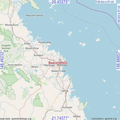
Beaconsfield GPS coordinates[2]
21° 5' 28.356" South, 149° 9' 55.584" East
| Map corner | latitude | longitude |
|---|---|---|
| Upper-left | -20.43375°, | 148.46232° |
| Center: | -21.09121°, | 149.16544° |
| Lower-right: | -21.74577°, | 149.86857° |
| Map W x H: | 145.9×145.9 km | = 90.7×90.7mi |
| max Lat: | -10.58257° ⇑6.6% North |
| Beaconsfield: | -21.09121° |
| min Lat: | ⇓93.4% South -43.31423° |
| min Long | Beaconsfield | max Long |
| 113.53327° | 149.16544° | 153.61246° |
| W 55.2%⇐ | ⇒44.8% E |
Elevation
Elevation of Beaconsfield is 4 m = 13 ft, and this is 118 m = 387 ft below average elevation for this country.
| Max E: |
1715 m = 5627 ft | 98.1% |
| Avg. | 122 m = 400 ft | |
| Beaconsfield | 4 m = 13 ft | |
Min E: |
-2 m = -7 ft | 1.9% |
See also: Australia elevation on elevation.city.
Geographical zone
Beaconsfield is located in South Torrid zone (between Equator and Tropic of Capricorn). Distance of this Southern Tropic circle is 260.8 km =162.1 mi to South.| Distance of | km | miles | from Beaconsfield |
|---|---|---|---|
| Equator | 2345.1 | 1457.2 | to North |
| Tropic Capricorn | 260.8 | 162.1 | to South |
| Antarctic Circle | 5056.1 | 3141.7 | to South |
| South Pole | 7661.9 | 4760.9 | to South |


Nearby cities:
15 places around Beaconsfield: (largest is in red/bold)
• Andergrove
2.1 km =1.3 mi,  64°
64°
• Blacks Beach
4.8 km =3 mi,  31°
31°
• Bucasia
6.3 km =3.9 mi,  352°
352°
• Eimeo
6.1 km =3.8 mi,  10°
10°
• Erakala
6.5 km =4 mi,  230°
230°
• Farleigh
6.7 km =4.2 mi,  256°
256°
• Glenella
3.7 km =2.3 mi,  216°
216°
• Mackay
6.9 km =4.3 mi,  179°
179°
• Mackay City
6.3 km =3.9 mi,  159°
159°
• Mackay Harbour
5.1 km =3.2 mi,  112°
112°
• Mount Pleasant
3.1 km =1.9 mi,  191°
191°
• North Mackay
3.5 km =2.2 mi, 155°
• Rural View
3 km =1.9 mi,  358°
358°
• Slade Point
6.4 km =4 mi,  73°
73°
• West Mackay
7.1 km =4.4 mi, 183°
Sources, notices
• [Note1] Compared only with cities in Australia existing in our database
• [Src1] Map data: © OpenStreetMap contributors (CC-BY-SA)
• [Src2] Other city data from geonames.org with taken over terms of usage.
• [Src3] Geographical zone / Annual Mean Temperature by Robert A. Rohde @ Wikipedia
