Gympie geodata
Gympie (Queensland) is a populated place; located in Australia in Australia/Brisbane (GMT+10) time zone. With population of 10,805 people, there are 507 cities with bigger population in this country. Compared to other cities in Australia, 88.4% of cities are located further ↓South; 85.4% of cities are located further ←West and 61.7% of cities have lower elevation than Gympie. Note1


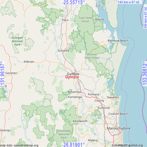
Gympie GPS coordinates[2]
26° 11' 23.244" South, 152° 39' 53.964" East
| Map corner | latitude | longitude |
|---|---|---|
| Upper-left | -25.55715°, | 151.96187° |
| Center: | -26.18979°, | 152.66499° |
| Lower-right: | -26.81901°, | 153.36812° |
| Map W x H: | 140.3×140.3 km | = 87.2×87.2mi |
| max Lat: | -10.58257° ⇑11.6% North |
| Gympie: | -26.18979° |
| min Lat: | ⇓88.4% South -43.31423° |
| min Long | Gympie | max Long |
| 113.53327° | 152.66499° | 153.61246° |
| W 85.4%⇐ | ⇒14.6% E |
Elevation
Elevation of Gympie is 69 m = 226 ft, and this is 53 m = 174 ft below average elevation for this country.
| Max E: |
1715 m = 5627 ft | 38.3% |
| Avg. | 122 m = 400 ft | |
| Gympie | 69 m = 226 ft | |
Min E: |
-2 m = -7 ft | 61.7% |
See also: Australia elevation on elevation.city.
Geographical zone
Gympie is located in South temperate zone (between Tropic of Capricorn and the Antarctic Circle). Distance of this Southern Tropic circle is 306.1 km =190.2 mi to North.| Distance of | km | miles | from Gympie |
|---|---|---|---|
| Equator | 2912 | 1809.4 | to North |
| Tropic Capricorn | 306.1 | 190.2 | to North |
| Antarctic Circle | 4489.1 | 2789.4 | to South |
| South Pole | 7095 | 4408.6 | to South |


Nearby cities:
15 places around Gympie: (largest is in red/bold)
• Amamoor
17.8 km =11.1 mi,  175°
175°
• Araluen
3.9 km =2.4 mi,  340°
340°
• Chatsworth
7.1 km =4.4 mi,  315°
315°
• Curra
15.9 km =9.9 mi,  329°
329°
• East Deep Creek
5.3 km =3.3 mi,  99°
99°
• Jones Hill
4.4 km =2.7 mi, 175°
• Monkland
3 km =1.9 mi,  144°
144°
• Mothar Mountain
12.7 km =7.9 mi,  121°
121°
• Pie Creek
7.2 km =4.5 mi,  232°
232°
• Southside
2.9 km =1.8 mi,  218°
218°
• Tamaree
6.1 km =3.8 mi,  358°
358°
• The Dawn
6 km =3.7 mi,  166°
166°
• The Palms
8 km =5 mi,  257°
257°
• Veteran
4.2 km =2.6 mi,  35°
35°
• Victory Heights
3.1 km =1.9 mi,  51°
51°
Sources, notices
• [Note1] Compared only with cities in Australia existing in our database
• [Src1] Map data: © OpenStreetMap contributors (CC-BY-SA)
• [Src2] Other city data from geonames.org with taken over terms of usage.
• [Src3] Geographical zone / Annual Mean Temperature by Robert A. Rohde @ Wikipedia
