The Palms geodata
The Palms (Queensland) is a populated place; located in Australia in Australia/Brisbane (GMT+10) time zone. With population of 998 people, there are 3821 cities with bigger population in this country. Compared to other cities in Australia, 88.4% of cities are located further ↓South; 85% of cities are located further ←West and 66.1% of cities have lower elevation than The Palms. Note1


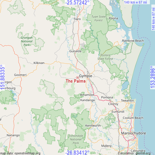
The Palms GPS coordinates[2]
26° 12' 17.928" South, 152° 35' 11.292" East
| Map corner | latitude | longitude |
|---|---|---|
| Upper-left | -25.57242°, | 151.88335° |
| Center: | -26.20498°, | 152.58647° |
| Lower-right: | -26.83412°, | 153.2896° |
| Map W x H: | 140.3×140.3 km | = 87.2×87.2mi |
| max Lat: | -10.58257° ⇑11.6% North |
| The Palms: | -26.20498° |
| min Lat: | ⇓88.4% South -43.31423° |
| min Long | The Palms | max Long |
| 113.53327° | 152.58647° | 153.61246° |
| W 85%⇐ | ⇒15% E |
Elevation
Elevation of The Palms is 84 m = 276 ft, and this is 38 m = 125 ft below average elevation for this country.
| Max E: |
1715 m = 5627 ft | 33.9% |
| Avg. | 122 m = 400 ft | |
| The Palms | 84 m = 276 ft | |
Min E: |
-2 m = -7 ft | 66.1% |
See also: Australia elevation on elevation.city.
Geographical zone
The Palms is located in South temperate zone (between Tropic of Capricorn and the Antarctic Circle). Distance of this Southern Tropic circle is 307.8 km =191.3 mi to North.| Distance of | km | miles | from The Palms |
|---|---|---|---|
| Equator | 2913.7 | 1810.5 | to North |
| Tropic Capricorn | 307.8 | 191.3 | to North |
| Antarctic Circle | 4487.5 | 2788.4 | to South |
| South Pole | 7093.3 | 4407.6 | to South |


Nearby cities:
15 places around The Palms: (largest is in red/bold)
• Amamoor
18.5 km =11.5 mi,  150°
150°
• Araluen
8.4 km =5.2 mi,  50°
50°
• Chatsworth
7.4 km =4.6 mi,  22°
22°
• Curra
15.4 km =9.6 mi,  358°
358°
• East Deep Creek
13.1 km =8.1 mi,  86°
86°
• Gympie
8 km =5 mi,  77°
77°
• Jones Hill
8.6 km =5.3 mi,  108°
108°
• Monkland
9.6 km =6 mi, 94°
• Pie Creek
3.5 km =2.2 mi,  142°
142°
• Southside
6.1 km =3.8 mi,  95°
95°
• Tamaree
11 km =6.8 mi,  44°
44°
• The Dawn
10.1 km =6.3 mi, 113°
• Veteran
11.5 km =7.1 mi,  63°
63°
• Victory Heights
10.9 km =6.8 mi,  70°
70°
• Widgee
15.6 km =9.7 mi,  264°
264°
Sources, notices
• [Note1] Compared only with cities in Australia existing in our database
• [Src1] Map data: © OpenStreetMap contributors (CC-BY-SA)
• [Src2] Other city data from geonames.org with taken over terms of usage.
• [Src3] Geographical zone / Annual Mean Temperature by Robert A. Rohde @ Wikipedia
