Gunnedah geodata
Gunnedah (New South Wales) is a populated place; located in Australia in Australia/Sydney (GMT+11) time zone. With population of 9,761 people, there are 623 cities with bigger population in this country. Compared to other cities in Australia, 70.9% of cities are located further ↓South; 57.8% of cities are located further ←West and 86.3% of cities have lower elevation than Gunnedah. Note1


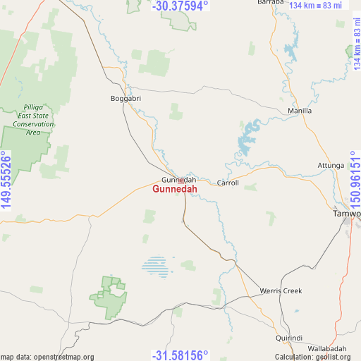
Gunnedah GPS coordinates[2]
30° 58' 50.34" South, 150° 15' 30.168" East
| Map corner | latitude | longitude |
|---|---|---|
| Upper-left | -30.37594°, | 149.55526° |
| Center: | -30.98065°, | 150.25838° |
| Lower-right: | -31.58156°, | 150.96151° |
| Map W x H: | 134.1×134.1 km | = 83.3×83.3mi |
| max Lat: | -10.58257° ⇑29.1% North |
| Gunnedah: | -30.98065° |
| min Lat: | ⇓70.9% South -43.31423° |
| min Long | Gunnedah | max Long |
| 113.53327° | 150.25838° | 153.61246° |
| W 57.8%⇐ | ⇒42.2% E |
Elevation
Elevation of Gunnedah is 273 m = 896 ft, and this is 151 m = 495 ft above average elevation for this country.
| Max E: |
1715 m = 5627 ft | 13.7% |
| Gunnedah | 273 m 896 ft | |
| Avg. | 122 m = 400 ft | |
Min E: |
-2 m = -7 ft | 86.3% |
See also: Australia elevation on elevation.city.
Geographical zone
Gunnedah is located in South temperate zone (between Tropic of Capricorn and the Antarctic Circle). Distance of this Southern Tropic circle is 838.8 km =521.2 mi to North.| Distance of | km | miles | from Gunnedah |
|---|---|---|---|
| Equator | 3444.7 | 2140.4 | to North |
| Tropic Capricorn | 838.8 | 521.2 | to North |
| Antarctic Circle | 3956.4 | 2458.4 | to South |
| South Pole | 6562.3 | 4077.6 | to South |


Nearby cities:
15 places around Gunnedah: (largest is in red/bold)
• Attunga
56.4 km =35 mi,  84°
84°
• Blair Athol
37.2 km =23.1 mi,  351°
351°
• Boggabri
36.6 km =22.7 mi,  325°
325°
• Curlewis
15.2 km =9.4 mi,  176°
176°
• Duri
59.6 km =37 mi,  115°
115°
• Hallsville
58.8 km =36.5 mi,  93°
93°
• Hillvue
63.9 km =39.7 mi,  104°
104°
• Manilla
51.1 km =31.8 mi,  59°
59°
• Moore
62.1 km =38.6 mi, 91°
• North Tamworth
64.2 km =39.9 mi, 99°
• Oxley Vale
61.9 km =38.5 mi, 98°
• Phillip
58.9 km =36.6 mi,  106°
106°
• Werris Creek
55.3 km =34.4 mi,  137°
137°
• West Tamworth
64 km =39.8 mi, 102°
• Westdale
58.3 km =36.2 mi, 102°
Sources, notices
• [Note1] Compared only with cities in Australia existing in our database
• [Src1] Map data: © OpenStreetMap contributors (CC-BY-SA)
• [Src2] Other city data from geonames.org with taken over terms of usage.
• [Src3] Geographical zone / Annual Mean Temperature by Robert A. Rohde @ Wikipedia
