Boggabri geodata
Boggabri (New South Wales) is a populated place; located in Australia in Australia/Sydney (GMT+11) time zone. With population of 1,266 people, there are 3510 cities with bigger population in this country. Compared to other cities in Australia, 71.3% of cities are located further ↓South; 57% of cities are located further ←West and 85.5% of cities have lower elevation than Boggabri. Note1


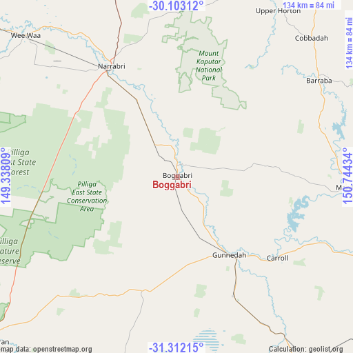
Boggabri GPS coordinates[2]
30° 42' 34.308" South, 150° 2' 28.356" East
| Map corner | latitude | longitude |
|---|---|---|
| Upper-left | -30.10312°, | 149.33809° |
| Center: | -30.70953°, | 150.04121° |
| Lower-right: | -31.31215°, | 150.74434° |
| Map W x H: | 134.4×134.4 km | = 83.5×83.5mi |
| max Lat: | -10.58257° ⇑28.7% North |
| Boggabri: | -30.70953° |
| min Lat: | ⇓71.3% South -43.31423° |
| min Long | Boggabri | max Long |
| 113.53327° | 150.04121° | 153.61246° |
| W 57%⇐ | ⇒43% E |
Elevation
Elevation of Boggabri is 256 m = 840 ft, and this is 134 m = 440 ft above average elevation for this country.
| Max E: |
1715 m = 5627 ft | 14.5% |
| Boggabri | 256 m 840 ft | |
| Avg. | 122 m = 400 ft | |
Min E: |
-2 m = -7 ft | 85.5% |
See also: Australia elevation on elevation.city.
Geographical zone
Boggabri is located in South temperate zone (between Tropic of Capricorn and the Antarctic Circle). Distance of this Southern Tropic circle is 808.7 km =502.5 mi to North.| Distance of | km | miles | from Boggabri |
|---|---|---|---|
| Equator | 3414.6 | 2121.7 | to North |
| Tropic Capricorn | 808.7 | 502.5 | to North |
| Antarctic Circle | 3986.6 | 2477.2 | to South |
| South Pole | 6592.5 | 4096.4 | to South |


Nearby cities:
15 places around Boggabri: (largest is in red/bold)
• Attunga
80.7 km =50.1 mi,  107°
107°
• Barraba
65.2 km =40.5 mi,  56°
56°
• Blair Athol
16.6 km =10.3 mi,  66°
66°
• Curlewis
50.2 km =31.2 mi,  154°
154°
• Duri
93.2 km =57.9 mi,  127°
127°
• Gunnedah
36.6 km =22.7 mi, 145°
• Hallsville
86.3 km =53.6 mi, 112°
• Manilla
65 km =40.4 mi,  93°
93°
• Moore
88.7 km =55.1 mi, 110°
• Narrabri
49.4 km =30.7 mi,  329°
329°
• Oxley Vale
90.9 km =56.5 mi,  115°
115°
• Phillip
90.4 km =56.2 mi, 121°
• Wee Waa
78.7 km =48.9 mi,  313°
313°
• Werris Creek
91.7 km =57 mi,  140°
140°
• Westdale
88.6 km =55.1 mi, 118°
Sources, notices
• [Note1] Compared only with cities in Australia existing in our database
• [Src1] Map data: © OpenStreetMap contributors (CC-BY-SA)
• [Src2] Other city data from geonames.org with taken over terms of usage.
• [Src3] Geographical zone / Annual Mean Temperature by Robert A. Rohde @ Wikipedia
