Gundaroo geodata
Gundaroo (New South Wales) is a populated place; located in Australia in Australia/Sydney (GMT+11) time zone. With population of 1,134 people, there are 3659 cities with bigger population in this country. Compared to other cities in Australia, 72.3% of cities are located further ↑North; 55.7% of cities are located further ←West and 94.8% of cities have lower elevation than Gundaroo. Note1


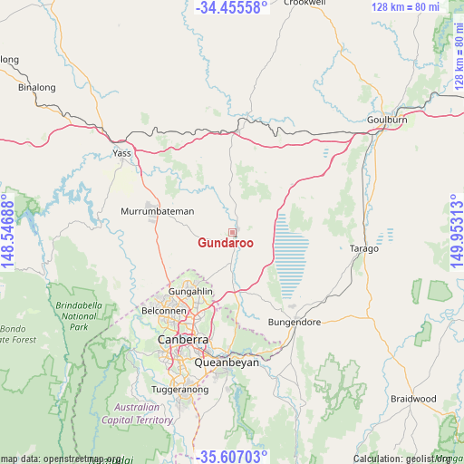
Gundaroo GPS coordinates[2]
35° 1' 59.988" South, 149° 15' 0" East
| Map corner | latitude | longitude |
|---|---|---|
| Upper-left | -34.45558°, | 148.54688° |
| Center: | -35.03333°, | 149.25° |
| Lower-right: | -35.60703°, | 149.95313° |
| Map W x H: | 128×128 km | = 79.5×79.5mi |
| max Lat: | -10.58257° ⇑72.3% North |
| Gundaroo: | -35.03333° |
| min Lat: | ⇓27.7% South -43.31423° |
| min Long | Gundaroo | max Long |
| 113.53327° | 149.25° | 153.61246° |
| W 55.7%⇐ | ⇒44.3% E |
Elevation
Elevation of Gundaroo is 578 m = 1896 ft, and this is 456 m = 1496 ft above average elevation for this country.
| Max E: |
1715 m = 5627 ft | 5.2% |
| Gundaroo | 578 m 1896 ft | |
| Avg. | 122 m = 400 ft | |
Min E: |
-2 m = -7 ft | 94.8% |
See also: Australia elevation on elevation.city.
Geographical zone
Gundaroo is located in South temperate zone (between Tropic of Capricorn and the Antarctic Circle). Distance of this Southern Tropic circle is 1289.4 km =801.2 mi to North.| Distance of | km | miles | from Gundaroo |
|---|---|---|---|
| Equator | 3895.3 | 2420.4 | to North |
| Tropic Capricorn | 1289.4 | 801.2 | to North |
| Antarctic Circle | 3505.8 | 2178.4 | to South |
| South Pole | 6111.7 | 3797.6 | to South |


Nearby cities:
15 places around Gundaroo: (largest is in red/bold)
• Amaroo
18.8 km =11.7 mi,  216°
216°
• Bonner
17.6 km =10.9 mi, 215°
• Bywong
16.3 km =10.1 mi,  153°
153°
• Casey
20.5 km =12.7 mi, 223°
• Crace
22.9 km =14.2 mi,  214°
214°
• Forde
17.7 km =11 mi, 212°
• Franklin
20.9 km =13 mi, 207°
• Gungahlin
20 km =12.4 mi, 211°
• Harrison
20.3 km =12.6 mi,  204°
204°
• Jacka
17.6 km =10.9 mi, 218°
• Murrumbateman
21.2 km =13.2 mi,  288°
288°
• Ngunnawal
20 km =12.4 mi, 219°
• Nicholls
22.1 km =13.7 mi, 219°
• Palmerston
21.5 km =13.4 mi, 213°
• Sutton
14.8 km =9.2 mi,  180°
180°
Sources, notices
• [Note1] Compared only with cities in Australia existing in our database
• [Src1] Map data: © OpenStreetMap contributors (CC-BY-SA)
• [Src2] Other city data from geonames.org with taken over terms of usage.
• [Src3] Geographical zone / Annual Mean Temperature by Robert A. Rohde @ Wikipedia
