Bywong geodata
Bywong (New South Wales) is a populated place; located in Australia in Australia/Sydney (GMT+11) time zone. With population of 1,287 people, there are 3484 cities with bigger population in this country. Compared to other cities in Australia, 73.8% of cities are located further ↑North; 55.9% of cities are located further ←West and 98.7% of cities have lower elevation than Bywong. Note1


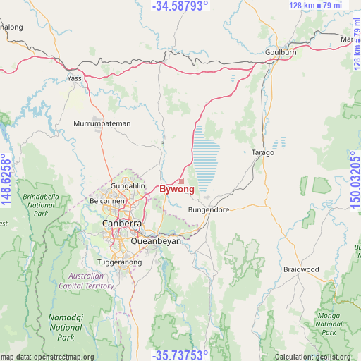
Bywong GPS coordinates[2]
35° 9' 53.136" South, 149° 19' 44.112" East
| Map corner | latitude | longitude |
|---|---|---|
| Upper-left | -34.58793°, | 148.6258° |
| Center: | -35.16476°, | 149.32892° |
| Lower-right: | -35.73753°, | 150.03205° |
| Map W x H: | 127.8×127.8 km | = 79.4×79.4mi |
| max Lat: | -10.58257° ⇑73.8% North |
| Bywong: | -35.16476° |
| min Lat: | ⇓26.2% South -43.31423° |
| min Long | Bywong | max Long |
| 113.53327° | 149.32892° | 153.61246° |
| W 55.9%⇐ | ⇒44.1% E |
Elevation
Elevation of Bywong is 753 m = 2470 ft, and this is 631 m = 2070 ft above average elevation for this country.
| Max E: |
1715 m = 5627 ft | 1.3% |
| Bywong | 753 m 2470 ft | |
| Avg. | 122 m = 400 ft | |
Min E: |
-2 m = -7 ft | 98.7% |
See also: Australia elevation on elevation.city.
Geographical zone
Bywong is located in South temperate zone (between Tropic of Capricorn and the Antarctic Circle). Distance of this Southern Tropic circle is 1304 km =810.3 mi to North.| Distance of | km | miles | from Bywong |
|---|---|---|---|
| Equator | 3910 | 2429.6 | to North |
| Tropic Capricorn | 1304 | 810.3 | to North |
| Antarctic Circle | 3491.2 | 2169.3 | to South |
| South Pole | 6097.1 | 3788.6 | to South |


Nearby cities:
15 places around Bywong: (largest is in red/bold)
• Amaroo
18.3 km =11.4 mi,  268°
268°
• Bonner
17.3 km =10.7 mi, 270°
• Bungendore
14.1 km =8.8 mi,  134°
134°
• Downer
18.9 km =11.7 mi,  242°
242°
• Forde
16.6 km =10.3 mi, 268°
• Franklin
17.3 km =10.7 mi,  257°
257°
• Gundaroo
16.3 km =10.1 mi,  333°
333°
• Gungahlin
17.7 km =11 mi, 262°
• Hackett
17.7 km =11 mi, 237°
• Harrison
16.1 km =10 mi, 256°
• Jacka
18.2 km =11.3 mi, 272°
• Palmerston
19.3 km =12 mi, 260°
• Sutton
7.2 km =4.5 mi, 268°
• Wamboin
9.6 km =6 mi,  177°
177°
• Watson
18 km =11.2 mi, 242°
Sources, notices
• [Note1] Compared only with cities in Australia existing in our database
• [Src1] Map data: © OpenStreetMap contributors (CC-BY-SA)
• [Src2] Other city data from geonames.org with taken over terms of usage.
• [Src3] Geographical zone / Annual Mean Temperature by Robert A. Rohde @ Wikipedia
