Gungahlin geodata
Gungahlin (ACT) is a section of populated place; located in Australia in Australia/Sydney (GMT+11) time zone. With population of 6,094 people, there are 1184 cities with bigger population in this country. Compared to other cities in Australia, 74.1% of cities are located further ↑North; 54.6% of cities are located further ←West and 96.8% of cities have lower elevation than Gungahlin. Note1


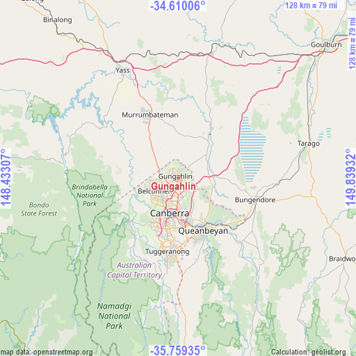
Gungahlin GPS coordinates[2]
35° 11' 12.264" South, 149° 8' 10.284" East
| Map corner | latitude | longitude |
|---|---|---|
| Upper-left | -34.61006°, | 148.43307° |
| Center: | -35.18674°, | 149.13619° |
| Lower-right: | -35.75935°, | 149.83932° |
| Map W x H: | 127.8×127.8 km | = 79.4×79.4mi |
| max Lat: | -10.58257° ⇑74.1% North |
| Gungahlin: | -35.18674° |
| min Lat: | ⇓25.9% South -43.31423° |
| min Long | Gungahlin | max Long |
| 113.53327° | 149.13619° | 153.61246° |
| W 54.6%⇐ | ⇒45.4% E |
Elevation
Elevation of Gungahlin is 627 m = 2057 ft, and this is 505 m = 1657 ft above average elevation for this country.
| Max E: |
1715 m = 5627 ft | 3.2% |
| Gungahlin | 627 m 2057 ft | |
| Avg. | 122 m = 400 ft | |
Min E: |
-2 m = -7 ft | 96.8% |
See also: Australia elevation on elevation.city.
Geographical zone
Gungahlin is located in South temperate zone (between Tropic of Capricorn and the Antarctic Circle). Distance of this Southern Tropic circle is 1306.5 km =811.8 mi to North.| Distance of | km | miles | from Gungahlin |
|---|---|---|---|
| Equator | 3912.4 | 2431.1 | to North |
| Tropic Capricorn | 1306.5 | 811.8 | to North |
| Antarctic Circle | 3488.8 | 2167.8 | to South |
| South Pole | 6094.7 | 3787.1 | to South |


Nearby cities:
15 places around Gungahlin: (largest is in red/bold)
• Amaroo
2 km =1.2 mi,  338°
338°
• Bonner
2.7 km =1.7 mi,  4°
4°
• Casey
4.4 km =2.7 mi,  300°
300°
• Crace
3.2 km =2 mi,  235°
235°
• Forde
2.2 km =1.4 mi,  23°
23°
• Franklin
1.6 km =1 mi,  155°
155°
• Giralang
4.5 km =2.8 mi,  233°
233°
• Harrison
2.3 km =1.4 mi,  126°
126°
• Jacka
3.4 km =2.1 mi,  348°
348°
• Kaleen
4.5 km =2.8 mi,  218°
218°
• Lyneham
5.9 km =3.7 mi,  184°
184°
• Ngunnawal
2.7 km =1.7 mi, 304°
• Nicholls
3.6 km =2.2 mi,  268°
268°
• Palmerston
1.8 km =1.1 mi, 240°
• Watson
5.9 km =3.7 mi,  165°
165°
Sources, notices
• [Note1] Compared only with cities in Australia existing in our database
• [Src1] Map data: © OpenStreetMap contributors (CC-BY-SA)
• [Src2] Other city data from geonames.org with taken over terms of usage.
• [Src3] Geographical zone / Annual Mean Temperature by Robert A. Rohde @ Wikipedia
