Gorokan geodata
Gorokan (New South Wales) is a section of populated place; located in Australia in Australia/Sydney (GMT+11) time zone. With population of 8,211 people, there are 799 cities with bigger population in this country. Compared to other cities in Australia, 55.8% of cities are located further ↓South; 77.9% of cities are located further ←West and 86.8% of cities have higher elevation than Gorokan. Note1


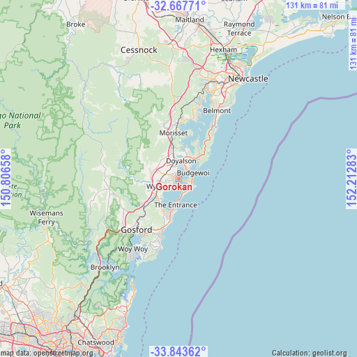
Gorokan GPS coordinates[2]
33° 15' 27.504" South, 151° 30' 34.92" East
| Map corner | latitude | longitude |
|---|---|---|
| Upper-left | -32.66771°, | 150.80658° |
| Center: | -33.25764°, | 151.5097° |
| Lower-right: | -33.84362°, | 152.21283° |
| Map W x H: | 130.7×130.7 km | = 81.2×81.2mi |
| max Lat: | -10.58257° ⇑44.2% North |
| Gorokan: | -33.25764° |
| min Lat: | ⇓55.8% South -43.31423° |
| min Long | Gorokan | max Long |
| 113.53327° | 151.5097° | 153.61246° |
| W 77.9%⇐ | ⇒22.1% E |
Elevation
Elevation of Gorokan is 11 m = 36 ft, and this is 111 m = 364 ft below average elevation for this country.
| Max E: |
1715 m = 5627 ft | 86.8% |
| Avg. | 122 m = 400 ft | |
| Gorokan | 11 m = 36 ft | |
Min E: |
-2 m = -7 ft | 13.2% |
See also: Australia elevation on elevation.city.
Geographical zone
Gorokan is located in South temperate zone (between Tropic of Capricorn and the Antarctic Circle). Distance of this Southern Tropic circle is 1092 km =678.5 mi to North.| Distance of | km | miles | from Gorokan |
|---|---|---|---|
| Equator | 3697.9 | 2297.8 | to North |
| Tropic Capricorn | 1092 | 678.5 | to North |
| Antarctic Circle | 3703.3 | 2301.1 | to South |
| South Pole | 6309.2 | 3920.4 | to South |


Nearby cities:
15 places around Gorokan: (largest is in red/bold)
• Blue Haven
5.2 km =3.2 mi,  353°
353°
• Budgewoi
4.9 km =3 mi,  57°
57°
• Buff Point
4.4 km =2.7 mi,  27°
27°
• Canton Beach
3.9 km =2.4 mi,  118°
118°
• Charmhaven
3.5 km =2.2 mi, 349°
• Hamlyn Terrace
3.2 km =2 mi,  282°
282°
• Kanwal
1.8 km =1.1 mi,  286°
286°
• Lake Haven
1.7 km =1.1 mi,  342°
342°
• Noraville
4.2 km =2.6 mi,  105°
105°
• San Remo
4.9 km =3 mi,  12°
12°
• Toukley
2.8 km =1.7 mi,  104°
104°
• Tuggerawong
3.7 km =2.3 mi,  227°
227°
• Wadalba
4.5 km =2.8 mi,  248°
248°
• Woongarrah
3.6 km =2.2 mi,  299°
299°
• Wyongah
2.7 km =1.7 mi, 225°
Sources, notices
• [Note1] Compared only with cities in Australia existing in our database
• [Src1] Map data: © OpenStreetMap contributors (CC-BY-SA)
• [Src2] Other city data from geonames.org with taken over terms of usage.
• [Src3] Geographical zone / Annual Mean Temperature by Robert A. Rohde @ Wikipedia
