Noraville geodata
Noraville (New South Wales) is a section of populated place; located in Australia in Australia/Sydney (GMT+11) time zone. With population of 2,855 people, there are 2342 cities with bigger population in this country. Compared to other cities in Australia, 55.7% of cities are located further ↓South; 78.3% of cities are located further ←West and 88.3% of cities have higher elevation than Noraville. Note1


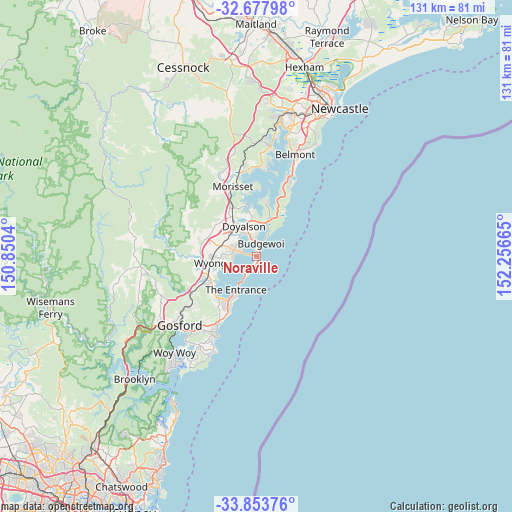
Noraville GPS coordinates[2]
33° 16' 4.26" South, 151° 33' 12.672" East
| Map corner | latitude | longitude |
|---|---|---|
| Upper-left | -32.67798°, | 150.8504° |
| Center: | -33.26785°, | 151.55352° |
| Lower-right: | -33.85376°, | 152.25665° |
| Map W x H: | 130.7×130.7 km | = 81.2×81.2mi |
| max Lat: | -10.58257° ⇑44.3% North |
| Noraville: | -33.26785° |
| min Lat: | ⇓55.7% South -43.31423° |
| min Long | Noraville | max Long |
| 113.53327° | 151.55352° | 153.61246° |
| W 78.3%⇐ | ⇒21.7% E |
Elevation
Elevation of Noraville is 10 m = 33 ft, and this is 112 m = 367 ft below average elevation for this country.
| Max E: |
1715 m = 5627 ft | 88.3% |
| Avg. | 122 m = 400 ft | |
| Noraville | 10 m = 33 ft | |
Min E: |
-2 m = -7 ft | 11.7% |
See also: Australia elevation on elevation.city.
Geographical zone
Noraville is located in South temperate zone (between Tropic of Capricorn and the Antarctic Circle). Distance of this Southern Tropic circle is 1093.1 km =679.2 mi to North.| Distance of | km | miles | from Noraville |
|---|---|---|---|
| Equator | 3699 | 2298.5 | to North |
| Tropic Capricorn | 1093.1 | 679.2 | to North |
| Antarctic Circle | 3702.1 | 2300.4 | to South |
| South Pole | 6308 | 3919.6 | to South |


Nearby cities:
15 places around Noraville: (largest is in red/bold)
• Blue Haven
7.8 km =4.8 mi,  323°
323°
• Budgewoi
3.8 km =2.4 mi,  0°
0°
• Buff Point
5.4 km =3.4 mi,  337°
337°
• Canton Beach
1 km =0.6 mi,  223°
223°
• Charmhaven
6.6 km =4.1 mi,  314°
314°
• Gorokan
4.2 km =2.6 mi,  285°
285°
• Halekulani
5.4 km =3.4 mi,  359°
359°
• Hamlyn Terrace
7.4 km =4.6 mi,  284°
284°
• Kanwal
6 km =3.7 mi, 285°
• Lake Haven
5.3 km =3.3 mi,  301°
301°
• San Remo
6.6 km =4.1 mi,  332°
332°
• Toukley
1.5 km =0.9 mi, 288°
• Tuggerawong
6.9 km =4.3 mi,  258°
258°
• Woongarrah
7.8 km =4.8 mi, 292°
• Wyongah
6 km =3.7 mi, 262°
Sources, notices
• [Note1] Compared only with cities in Australia existing in our database
• [Src1] Map data: © OpenStreetMap contributors (CC-BY-SA)
• [Src2] Other city data from geonames.org with taken over terms of usage.
• [Src3] Geographical zone / Annual Mean Temperature by Robert A. Rohde @ Wikipedia
