Ganmain geodata
Ganmain (New South Wales) is a populated place; located in Australia in Australia/Sydney (GMT+11) time zone. With population of 765 people, there are 4215 cities with bigger population in this country. Compared to other cities in Australia, 65.7% of cities are located further ↑North; 52.9% of cities are located further →East and 80.9% of cities have lower elevation than Ganmain. Note1


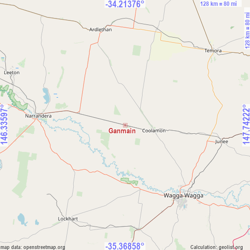
Ganmain GPS coordinates[2]
34° 47' 35.484" South, 147° 2' 20.724" East
| Map corner | latitude | longitude |
|---|---|---|
| Upper-left | -34.21376°, | 146.33597° |
| Center: | -34.79319°, | 147.03909° |
| Lower-right: | -35.36858°, | 147.74222° |
| Map W x H: | 128.4×128.4 km | = 79.8×79.8mi |
| max Lat: | -10.58257° ⇑65.7% North |
| Ganmain: | -34.79319° |
| min Lat: | ⇓34.3% South -43.31423° |
| min Long | Ganmain | max Long |
| 113.53327° | 147.03909° | 153.61246° |
| W 47.1%⇐ | ⇒52.9% E |
Elevation
Elevation of Ganmain is 192 m = 630 ft, and this is 70 m = 230 ft above average elevation for this country.
| Max E: |
1715 m = 5627 ft | 19.1% |
| Ganmain | 192 m 630 ft | |
| Avg. | 122 m = 400 ft | |
Min E: |
-2 m = -7 ft | 80.9% |
See also: Australia elevation on elevation.city.
Geographical zone
Ganmain is located in South temperate zone (between Tropic of Capricorn and the Antarctic Circle). Distance of this Southern Tropic circle is 1262.7 km =784.6 mi to North.| Distance of | km | miles | from Ganmain |
|---|---|---|---|
| Equator | 3868.6 | 2403.8 | to North |
| Tropic Capricorn | 1262.7 | 784.6 | to North |
| Antarctic Circle | 3532.5 | 2195 | to South |
| South Pole | 6138.4 | 3814.2 | to South |


Nearby cities:
15 places around Ganmain: (largest is in red/bold)
• Ashmont
45.5 km =28.3 mi,  144°
144°
• Boorooma
43.1 km =26.8 mi, 136°
• Bourkelands
49.1 km =30.5 mi,  145°
145°
• Charles Sturt University
41.4 km =25.7 mi, 135°
• Coolamon
14.5 km =9 mi,  100°
100°
• Estella
42.5 km =26.4 mi, 136°
• Glenfield Park
46.7 km =29 mi, 145°
• Kapooka
46.2 km =28.7 mi, 151°
• Lloyd
48.1 km =29.9 mi, 145°
• Mount Austin
47.7 km =29.6 mi, 143°
• Narrandera
44.9 km =27.9 mi,  276°
276°
• Tolland
48.4 km =30.1 mi, 143°
• Turvey Park
47.5 km =29.5 mi, 141°
• Uranquinty
48.3 km =30 mi,  157°
157°
• Wagga Wagga
46.8 km =29.1 mi, 142°
Sources, notices
• [Note1] Compared only with cities in Australia existing in our database
• [Src1] Map data: © OpenStreetMap contributors (CC-BY-SA)
• [Src2] Other city data from geonames.org with taken over terms of usage.
• [Src3] Geographical zone / Annual Mean Temperature by Robert A. Rohde @ Wikipedia
