Elmore geodata
Elmore (Victoria) is a populated place; located in Australia in Australia/Melbourne (GMT+11) time zone. With population of 763 people, there are 4219 cities with bigger population in this country. Compared to other cities in Australia, 80% of cities are located further ↑North; 69.8% of cities are located further →East and 75.2% of cities have lower elevation than Elmore. Note1


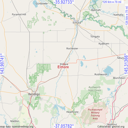
Elmore GPS coordinates[2]
36° 29' 40.704" South, 144° 36' 37.908" East
| Map corner | latitude | longitude |
|---|---|---|
| Upper-left | -35.92733°, | 143.90741° |
| Center: | -36.49464°, | 144.61053° |
| Lower-right: | -37.05782°, | 145.31366° |
| Map W x H: | 125.7×125.7 km | = 78.1×78.1mi |
| max Lat: | -10.58257° ⇑80% North |
| Elmore: | -36.49464° |
| min Lat: | ⇓20% South -43.31423° |
| min Long | Elmore | max Long |
| 113.53327° | 144.61053° | 153.61246° |
| W 30.2%⇐ | ⇒69.8% E |
Elevation
Elevation of Elmore is 133 m = 436 ft, and this is 11 m = 36 ft above average elevation for this country.
| Max E: |
1715 m = 5627 ft | 24.8% |
| Elmore | 133 m 436 ft | |
| Avg. | 122 m = 400 ft | |
Min E: |
-2 m = -7 ft | 75.2% |
See also: Australia elevation on elevation.city.
Geographical zone
Elmore is located in South temperate zone (between Tropic of Capricorn and the Antarctic Circle). Distance of this Southern Tropic circle is 1451.9 km =902.2 mi to North.| Distance of | km | miles | from Elmore |
|---|---|---|---|
| Equator | 4057.8 | 2521.4 | to North |
| Tropic Capricorn | 1451.9 | 902.2 | to North |
| Antarctic Circle | 3343.4 | 2077.5 | to South |
| South Pole | 5949.2 | 3696.7 | to South |


Nearby cities:
15 places around Elmore: (largest is in red/bold)
• Ascot
33.7 km =20.9 mi,  227°
227°
• Axedale
35 km =21.7 mi,  193°
193°
• East Bendigo
37.8 km =23.5 mi,  223°
223°
• Epsom
36 km =22.4 mi, 226°
• Girgarre
32.1 km =19.9 mi,  70°
70°
• Goornong
16.4 km =10.2 mi,  214°
214°
• Huntly
31.1 km =19.3 mi, 232°
• Jackass Flat
38 km =23.6 mi, 229°
• Junortoun
37.8 km =23.5 mi, 215°
• Lockington
25.7 km =16 mi,  345°
345°
• North Bendigo
39.9 km =24.8 mi, 226°
• Rochester
16.7 km =10.4 mi,  28°
28°
• Rushworth
37.8 km =23.5 mi,  105°
105°
• Stanhope
33.7 km =20.9 mi,  81°
81°
• White Hills
37.7 km =23.4 mi, 226°
Sources, notices
• [Note1] Compared only with cities in Australia existing in our database
• [Src1] Map data: © OpenStreetMap contributors (CC-BY-SA)
• [Src2] Other city data from geonames.org with taken over terms of usage.
• [Src3] Geographical zone / Annual Mean Temperature by Robert A. Rohde @ Wikipedia
