Rushworth geodata
Rushworth (Victoria) is a populated place; located in Australia in Australia/Melbourne (GMT+11) time zone. With population of 1,315 people, there are 3461 cities with bigger population in this country. Compared to other cities in Australia, 80.2% of cities are located further ↑North; 66% of cities are located further →East and 77% of cities have lower elevation than Rushworth. Note1


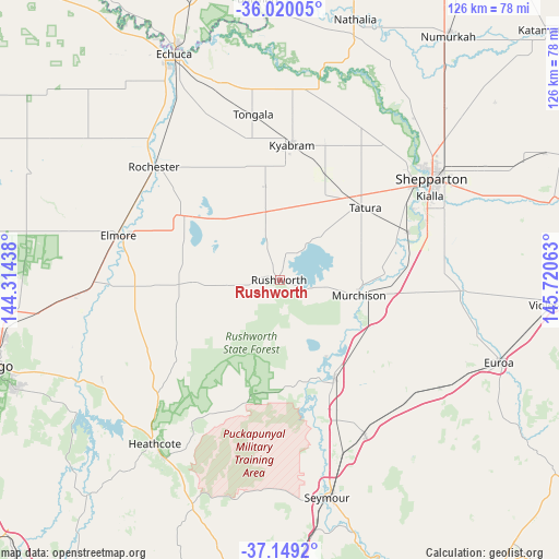
Rushworth GPS coordinates[2]
36° 35' 12.084" South, 145° 1' 3" East
| Map corner | latitude | longitude |
|---|---|---|
| Upper-left | -36.02005°, | 144.31438° |
| Center: | -36.58669°, | 145.0175° |
| Lower-right: | -37.1492°, | 145.72063° |
| Map W x H: | 125.5×125.5 km | = 78×78mi |
| max Lat: | -10.58257° ⇑80.2% North |
| Rushworth: | -36.58669° |
| min Lat: | ⇓19.8% South -43.31423° |
| min Long | Rushworth | max Long |
| 113.53327° | 145.0175° | 153.61246° |
| W 34%⇐ | ⇒66% E |
Elevation
Elevation of Rushworth is 148 m = 486 ft, and this is 26 m = 85 ft above average elevation for this country.
| Max E: |
1715 m = 5627 ft | 23% |
| Rushworth | 148 m 486 ft | |
| Avg. | 122 m = 400 ft | |
Min E: |
-2 m = -7 ft | 77% |
See also: Australia elevation on elevation.city.
Geographical zone
Rushworth is located in South temperate zone (between Tropic of Capricorn and the Antarctic Circle). Distance of this Southern Tropic circle is 1462.1 km =908.5 mi to North.| Distance of | km | miles | from Rushworth |
|---|---|---|---|
| Equator | 4068.1 | 2527.8 | to North |
| Tropic Capricorn | 1462.1 | 908.5 | to North |
| Antarctic Circle | 3333.1 | 2071.1 | to South |
| South Pole | 5939 | 3690.3 | to South |


Nearby cities:
15 places around Rushworth: (largest is in red/bold)
• Avenel
39.9 km =24.8 mi,  151°
151°
• Elmore
37.8 km =23.5 mi,  285°
285°
• Girgarre
21.6 km =13.4 mi,  343°
343°
• Kialla
38.7 km =24 mi,  66°
66°
• Kyabram
30.5 km =19 mi,  5°
5°
• Merrigum
25.9 km =16.1 mi,  23°
23°
• Mooroopna
36.3 km =22.6 mi,  55°
55°
• Murchison
18.2 km =11.3 mi,  101°
101°
• Nagambie
25.2 km =15.7 mi, 151°
• Rochester
37.7 km =23.4 mi,  311°
311°
• Shepparton
41.1 km =25.5 mi, 56°
• Stanhope
15.8 km =9.8 mi,  348°
348°
• Tatura
25.1 km =15.6 mi,  49°
49°
• Tongala
37.3 km =23.2 mi, 351°
• Toolamba
31.2 km =19.4 mi, 72°
Sources, notices
• [Note1] Compared only with cities in Australia existing in our database
• [Src1] Map data: © OpenStreetMap contributors (CC-BY-SA)
• [Src2] Other city data from geonames.org with taken over terms of usage.
• [Src3] Geographical zone / Annual Mean Temperature by Robert A. Rohde @ Wikipedia
