Woollahra geodata
Woollahra (New South Wales) is a section of populated place; located in Australia in Australia/Sydney (GMT+11) time zone. With population of 7,278 people, there are 938 cities with bigger population in this country. Compared to other cities in Australia, 55.4% of cities are located further ↑North; 74.3% of cities are located further ←West and 61.2% of cities have lower elevation than Woollahra. Note1


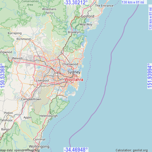
Woollahra GPS coordinates[2]
33° 53' 16.08" South, 151° 14' 12.516" East
| Map corner | latitude | longitude |
|---|---|---|
| Upper-left | -33.30212°, | 150.53369° |
| Center: | -33.8878°, | 151.23681° |
| Lower-right: | -34.46948°, | 151.93994° |
| Map W x H: | 129.8×129.8 km | = 80.7×80.7mi |
| max Lat: | -10.58257° ⇑55.4% North |
| Woollahra: | -33.8878° |
| min Lat: | ⇓44.6% South -43.31423° |
| min Long | Woollahra | max Long |
| 113.53327° | 151.23681° | 153.61246° |
| W 74.3%⇐ | ⇒25.7% E |
Elevation
Elevation of Woollahra is 67 m = 220 ft, and this is 55 m = 180 ft below average elevation for this country.
| Max E: |
1715 m = 5627 ft | 38.8% |
| Avg. | 122 m = 400 ft | |
| Woollahra | 67 m = 220 ft | |
Min E: |
-2 m = -7 ft | 61.2% |
See also: Australia elevation on elevation.city.
Geographical zone
Woollahra is located in South temperate zone (between Tropic of Capricorn and the Antarctic Circle). Distance of this Southern Tropic circle is 1162.1 km =722.1 mi to North.| Distance of | km | miles | from Woollahra |
|---|---|---|---|
| Equator | 3768 | 2341.3 | to North |
| Tropic Capricorn | 1162.1 | 722.1 | to North |
| Antarctic Circle | 3633.2 | 2257.6 | to South |
| South Pole | 6239.1 | 3876.8 | to South |


Nearby cities:
15 places around Woollahra: (largest is in red/bold)
• Bellevue Hill
1.6 km =1 mi,  53°
53°
• Bondi Junction
1.1 km =0.7 mi,  119°
119°
• Centennial Park
1.2 km =0.7 mi,  194°
194°
• Darling Point
1.9 km =1.2 mi,  5°
5°
• Darlinghurst
1.9 km =1.2 mi,  299°
299°
• Double Bay
1.3 km =0.8 mi,  29°
29°
• Edgecliff
0.9 km =0.6 mi,  359°
359°
• Elizabeth Bay
2 km =1.2 mi,  333°
333°
• Paddington
0.6 km =0.4 mi,  309°
309°
• Point Piper
2.6 km =1.6 mi, 27°
• Potts Point
2.5 km =1.6 mi,  336°
336°
• Queens Park
1.6 km =1 mi,  143°
143°
• Rushcutters Bay
1.7 km =1.1 mi, 330°
• Surry Hills
2.3 km =1.4 mi,  281°
281°
• Woolloomooloo
2.5 km =1.6 mi,  320°
320°
Sources, notices
• [Note1] Compared only with cities in Australia existing in our database
• [Src1] Map data: © OpenStreetMap contributors (CC-BY-SA)
• [Src2] Other city data from geonames.org with taken over terms of usage.
• [Src3] Geographical zone / Annual Mean Temperature by Robert A. Rohde @ Wikipedia
