Eagleby geodata
Eagleby (Queensland) is a section of populated place; located in Australia in Australia/Brisbane (GMT+10) time zone. With population of 13,198 people, there are 350 cities with bigger population in this country. Compared to other cities in Australia, 77.8% of cities are located further ↓South; 96.9% of cities are located further ←West and 98.1% of cities have higher elevation than Eagleby. Note1


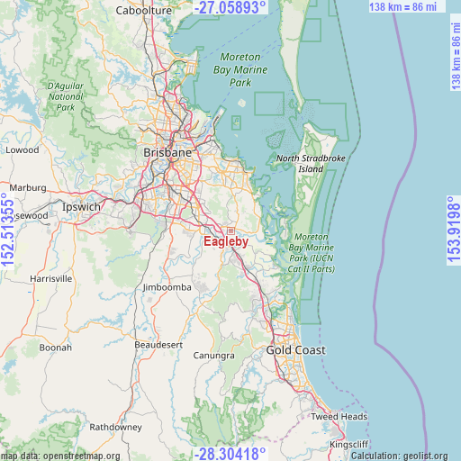
Eagleby GPS coordinates[2]
27° 40' 59.988" South, 153° 13' 0.012" East
| Map corner | latitude | longitude |
|---|---|---|
| Upper-left | -27.05893°, | 152.51355° |
| Center: | -27.68333°, | 153.21667° |
| Lower-right: | -28.30418°, | 153.9198° |
| Map W x H: | 138.5×138.5 km | = 86.1×86.1mi |
| max Lat: | -10.58257° ⇑22.2% North |
| Eagleby: | -27.68333° |
| min Lat: | ⇓77.8% South -43.31423° |
| min Long | Eagleby | max Long |
| 113.53327° | 153.21667° | 153.61246° |
| W 96.9%⇐ | ⇒3.1% E |
Elevation
Elevation of Eagleby is 4 m = 13 ft, and this is 118 m = 387 ft below average elevation for this country.
| Max E: |
1715 m = 5627 ft | 98.1% |
| Avg. | 122 m = 400 ft | |
| Eagleby | 4 m = 13 ft | |
Min E: |
-2 m = -7 ft | 1.9% |
See also: Australia elevation on elevation.city.
Geographical zone
Eagleby is located in South temperate zone (between Tropic of Capricorn and the Antarctic Circle). Distance of this Southern Tropic circle is 472.2 km =293.4 mi to North.| Distance of | km | miles | from Eagleby |
|---|---|---|---|
| Equator | 3078.1 | 1912.6 | to North |
| Tropic Capricorn | 472.2 | 293.4 | to North |
| Antarctic Circle | 4323.1 | 2686.2 | to South |
| South Pole | 6929 | 4305.5 | to South |


Nearby cities:
15 places around Eagleby: (largest is in red/bold)
• Alberton
3.8 km =2.4 mi,  119°
119°
• Bahrs Scrub
7.4 km =4.6 mi,  221°
221°
• Beenleigh
3.4 km =2.1 mi,  203°
203°
• Carbrook
3.3 km =2.1 mi,  90°
90°
• Cornubia
1.9 km =1.2 mi,  0°
0°
• Edens Landing
5.1 km =3.2 mi,  245°
245°
• Holmview
5.8 km =3.6 mi,  231°
231°
• Loganholme
3 km =1.9 mi,  267°
267°
• Meadowbrook
7.4 km =4.6 mi,  286°
286°
• Mount Cotton
5.8 km =3.6 mi,  16°
16°
• Mount Warren Park
5.4 km =3.4 mi,  191°
191°
• Shailer Park
5.4 km =3.4 mi,  314°
314°
• Tanah Merah
4.8 km =3 mi, 286°
• Windaroo
7.3 km =4.5 mi, 198°
• Yatala
3.7 km =2.3 mi,  180°
180°
Sources, notices
• [Note1] Compared only with cities in Australia existing in our database
• [Src1] Map data: © OpenStreetMap contributors (CC-BY-SA)
• [Src2] Other city data from geonames.org with taken over terms of usage.
• [Src3] Geographical zone / Annual Mean Temperature by Robert A. Rohde @ Wikipedia
