Windaroo geodata
Windaroo (Queensland) is a section of populated place; located in Australia in Australia/Brisbane (GMT+10) time zone. With population of 2,799 people, there are 2378 cities with bigger population in this country. Compared to other cities in Australia, 77.4% of cities are located further ↓South; 96.6% of cities are located further ←West and 70.9% of cities have higher elevation than Windaroo. Note1


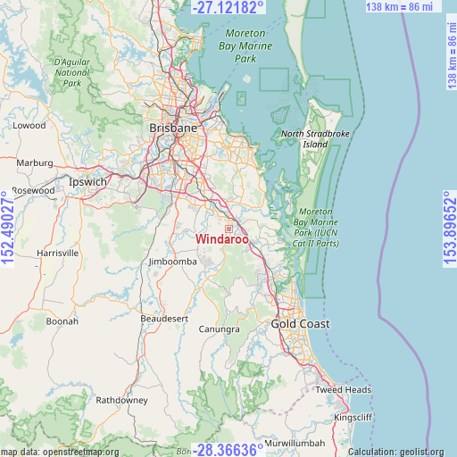
Windaroo GPS coordinates[2]
27° 44' 45.132" South, 153° 11' 36.204" East
| Map corner | latitude | longitude |
|---|---|---|
| Upper-left | -27.12182°, | 152.49027° |
| Center: | -27.74587°, | 153.19339° |
| Lower-right: | -28.36636°, | 153.89652° |
| Map W x H: | 138.4×138.4 km | = 86×86mi |
| max Lat: | -10.58257° ⇑22.6% North |
| Windaroo: | -27.74587° |
| min Lat: | ⇓77.4% South -43.31423° |
| min Long | Windaroo | max Long |
| 113.53327° | 153.19339° | 153.61246° |
| W 96.6%⇐ | ⇒3.4% E |
Elevation
Elevation of Windaroo is 22 m = 72 ft, and this is 100 m = 328 ft below average elevation for this country.
| Max E: |
1715 m = 5627 ft | 70.9% |
| Avg. | 122 m = 400 ft | |
| Windaroo | 22 m = 72 ft | |
Min E: |
-2 m = -7 ft | 29.1% |
See also: Australia elevation on elevation.city.
Geographical zone
Windaroo is located in South temperate zone (between Tropic of Capricorn and the Antarctic Circle). Distance of this Southern Tropic circle is 479.1 km =297.7 mi to North.| Distance of | km | miles | from Windaroo |
|---|---|---|---|
| Equator | 3085.1 | 1917 | to North |
| Tropic Capricorn | 479.1 | 297.7 | to North |
| Antarctic Circle | 4316.1 | 2681.9 | to South |
| South Pole | 6922 | 4301.1 | to South |


Nearby cities:
15 places around Windaroo: (largest is in red/bold)
• Alberton
7.6 km =4.7 mi,  47°
47°
• Bahrs Scrub
3 km =1.9 mi,  297°
297°
• Bannockburn
1.6 km =1 mi,  184°
184°
• Beenleigh
3.9 km =2.4 mi,  13°
13°
• Buccan
5.9 km =3.7 mi,  265°
265°
• Eagleby
7.3 km =4.5 mi,  18°
18°
• Edens Landing
5.3 km =3.3 mi,  333°
333°
• Holmview
4 km =2.5 mi, 325°
• Loganholme
6.9 km =4.3 mi,  354°
354°
• Mount Warren Park
2 km =1.2 mi,  35°
35°
• Ormeau
5.4 km =3.4 mi,  116°
116°
• Ormeau Hills
8.4 km =5.2 mi,  132°
132°
• Tanah Merah
8.6 km =5.3 mi,  344°
344°
• Waterford West
8.5 km =5.3 mi,  316°
316°
• Yatala
4 km =2.5 mi, 35°
Sources, notices
• [Note1] Compared only with cities in Australia existing in our database
• [Src1] Map data: © OpenStreetMap contributors (CC-BY-SA)
• [Src2] Other city data from geonames.org with taken over terms of usage.
• [Src3] Geographical zone / Annual Mean Temperature by Robert A. Rohde @ Wikipedia
