Doncaster geodata
Doncaster (Victoria) is a section of populated place; located in Australia in Australia/Melbourne (GMT+11) time zone. With population of 20,728 people, there are 156 cities with bigger population in this country. Compared to other cities in Australia, 87.2% of cities are located further ↑North; 63.9% of cities are located further →East and 70.8% of cities have lower elevation than Doncaster. Note1


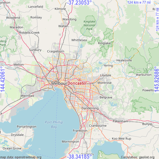
Doncaster GPS coordinates[2]
37° 47' 17.808" South, 145° 7' 25.428" East
| Map corner | latitude | longitude |
|---|---|---|
| Upper-left | -37.23053°, | 144.42061° |
| Center: | -37.78828°, | 145.12373° |
| Lower-right: | -38.34185°, | 145.82686° |
| Map W x H: | 123.6×123.6 km | = 76.8×76.8mi |
| max Lat: | -10.58257° ⇑87.2% North |
| Doncaster: | -37.78828° |
| min Lat: | ⇓12.8% South -43.31423° |
| min Long | Doncaster | max Long |
| 113.53327° | 145.12373° | 153.61246° |
| W 36.1%⇐ | ⇒63.9% E |
Elevation
Elevation of Doncaster is 108 m = 354 ft, and this is 14 m = 46 ft below average elevation for this country.
| Max E: |
1715 m = 5627 ft | 29.2% |
| Avg. | 122 m = 400 ft | |
| Doncaster | 108 m = 354 ft | |
Min E: |
-2 m = -7 ft | 70.8% |
See also: Australia elevation on elevation.city.
Geographical zone
Doncaster is located in South temperate zone (between Tropic of Capricorn and the Antarctic Circle). Distance of this Southern Tropic circle is 1595.7 km =991.5 mi to North.| Distance of | km | miles | from Doncaster |
|---|---|---|---|
| Equator | 4201.7 | 2610.8 | to North |
| Tropic Capricorn | 1595.7 | 991.5 | to North |
| Antarctic Circle | 3199.5 | 1988.1 | to South |
| South Pole | 5805.4 | 3607.3 | to South |


Nearby cities:
15 places around Doncaster: (largest is in red/bold)
• Balwyn
4.6 km =2.9 mi,  239°
239°
• Balwyn North
2.6 km =1.6 mi,  263°
263°
• Blackburn
4.3 km =2.7 mi,  142°
142°
• Blackburn North
3.4 km =2.1 mi,  133°
133°
• Box Hill
3.4 km =2.1 mi,  177°
177°
• Box Hill North
1.6 km =1 mi,  171°
171°
• Box Hill South
4.9 km =3 mi, 182°
• Bulleen
4.3 km =2.7 mi,  304°
304°
• Doncaster East
2.2 km =1.4 mi,  88°
88°
• Donvale
4.5 km =2.8 mi, 91°
• Mont Albert
3.6 km =2.2 mi,  202°
202°
• Mont Albert North
1.9 km =1.2 mi,  225°
225°
• Surrey Hills
3.8 km =2.4 mi,  213°
213°
• Templestowe
4.4 km =2.7 mi,  29°
29°
• Templestowe Lower
2.5 km =1.6 mi,  345°
345°
Sources, notices
• [Note1] Compared only with cities in Australia existing in our database
• [Src1] Map data: © OpenStreetMap contributors (CC-BY-SA)
• [Src2] Other city data from geonames.org with taken over terms of usage.
• [Src3] Geographical zone / Annual Mean Temperature by Robert A. Rohde @ Wikipedia
