Blackburn geodata
Blackburn (Victoria) is a section of populated place; located in Australia in Australia/Melbourne (GMT+11) time zone. With population of 13,703 people, there are 325 cities with bigger population in this country. Compared to other cities in Australia, 88.3% of cities are located further ↑North; 63.2% of cities are located further →East and 70.1% of cities have lower elevation than Blackburn. Note1


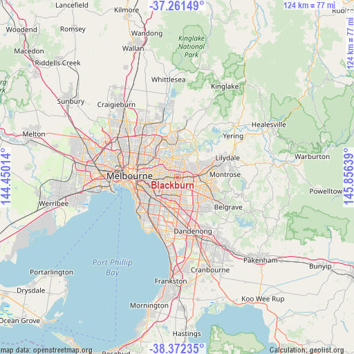
Blackburn GPS coordinates[2]
37° 49' 8.436" South, 145° 9' 11.736" East
| Map corner | latitude | longitude |
|---|---|---|
| Upper-left | -37.26149°, | 144.45014° |
| Center: | -37.81901°, | 145.15326° |
| Lower-right: | -38.37235°, | 145.85639° |
| Map W x H: | 123.5×123.5 km | = 76.7×76.7mi |
| max Lat: | -10.58257° ⇑88.3% North |
| Blackburn: | -37.81901° |
| min Lat: | ⇓11.7% South -43.31423° |
| min Long | Blackburn | max Long |
| 113.53327° | 145.15326° | 153.61246° |
| W 36.8%⇐ | ⇒63.2% E |
Elevation
Elevation of Blackburn is 104 m = 341 ft, and this is 18 m = 59 ft below average elevation for this country.
| Max E: |
1715 m = 5627 ft | 29.9% |
| Avg. | 122 m = 400 ft | |
| Blackburn | 104 m = 341 ft | |
Min E: |
-2 m = -7 ft | 70.1% |
See also: Australia elevation on elevation.city.
Geographical zone
Blackburn is located in South temperate zone (between Tropic of Capricorn and the Antarctic Circle). Distance of this Southern Tropic circle is 1599.2 km =993.7 mi to North.| Distance of | km | miles | from Blackburn |
|---|---|---|---|
| Equator | 4205.1 | 2612.9 | to North |
| Tropic Capricorn | 1599.2 | 993.7 | to North |
| Antarctic Circle | 3196.1 | 1986 | to South |
| South Pole | 5802 | 3605.2 | to South |


Nearby cities:
15 places around Blackburn: (largest is in red/bold)
• Blackburn North
1.1 km =0.7 mi,  353°
353°
• Blackburn South
2.3 km =1.4 mi,  175°
175°
• Box Hill
2.4 km =1.5 mi,  270°
270°
• Box Hill North
3 km =1.9 mi,  307°
307°
• Box Hill South
3.2 km =2 mi,  242°
242°
• Burwood East
3.5 km =2.2 mi, 184°
• Doncaster
4.3 km =2.7 mi,  322°
322°
• Doncaster East
3.5 km =2.2 mi, 353°
• Donvale
3.8 km =2.4 mi,  29°
29°
• Forest Hill
3.1 km =1.9 mi,  121°
121°
• Mitcham
4.1 km =2.5 mi,  86°
86°
• Mont Albert
4 km =2.5 mi, 271°
• Mont Albert North
4.5 km =2.8 mi,  297°
297°
• Nunawading
1.7 km =1.1 mi,  95°
95°
• Vermont
4.1 km =2.5 mi, 117°
Sources, notices
• [Note1] Compared only with cities in Australia existing in our database
• [Src1] Map data: © OpenStreetMap contributors (CC-BY-SA)
• [Src2] Other city data from geonames.org with taken over terms of usage.
• [Src3] Geographical zone / Annual Mean Temperature by Robert A. Rohde @ Wikipedia
