Dapto geodata
Dapto (New South Wales) is a section of populated place; located in Australia in Australia/Sydney (GMT+11) time zone. With population of 10,568 people, there are 532 cities with bigger population in this country. Compared to other cities in Australia, 63.4% of cities are located further ↑North; 62.2% of cities are located further ←West and 83.5% of cities have higher elevation than Dapto. Note1


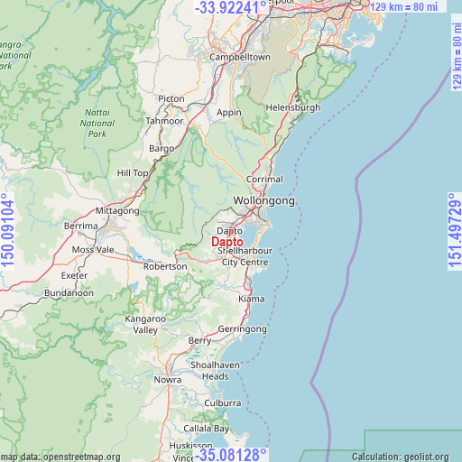
Dapto GPS coordinates[2]
34° 30' 13.896" South, 150° 47' 38.976" East
| Map corner | latitude | longitude |
|---|---|---|
| Upper-left | -33.92241°, | 150.09104° |
| Center: | -34.50386°, | 150.79416° |
| Lower-right: | -35.08128°, | 151.49729° |
| Map W x H: | 128.9×128.9 km | = 80.1×80.1mi |
| max Lat: | -10.58257° ⇑63.4% North |
| Dapto: | -34.50386° |
| min Lat: | ⇓36.6% South -43.31423° |
| min Long | Dapto | max Long |
| 113.53327° | 150.79416° | 153.61246° |
| W 62.2%⇐ | ⇒37.8% E |
Elevation
Elevation of Dapto is 13 m = 43 ft, and this is 109 m = 358 ft below average elevation for this country.
| Max E: |
1715 m = 5627 ft | 83.5% |
| Avg. | 122 m = 400 ft | |
| Dapto | 13 m = 43 ft | |
Min E: |
-2 m = -7 ft | 16.5% |
See also: Australia elevation on elevation.city.
Geographical zone
Dapto is located in South temperate zone (between Tropic of Capricorn and the Antarctic Circle). Distance of this Southern Tropic circle is 1230.6 km =764.7 mi to North.| Distance of | km | miles | from Dapto |
|---|---|---|---|
| Equator | 3836.5 | 2383.9 | to North |
| Tropic Capricorn | 1230.6 | 764.7 | to North |
| Antarctic Circle | 3564.7 | 2215 | to South |
| South Pole | 6170.6 | 3834.2 | to South |


Nearby cities:
15 places around Dapto: (largest is in red/bold)
• Albion Park Rail
7 km =4.3 mi,  181°
181°
• Avondale
4.3 km =2.7 mi,  249°
249°
• Berkeley
5.6 km =3.5 mi,  65°
65°
• Brownsville
2.8 km =1.7 mi,  33°
33°
• Farmborough Heights
5.7 km =3.5 mi,  17°
17°
• Haywards Bay
3.3 km =2.1 mi, 184°
• Horsley
2.3 km =1.4 mi,  320°
320°
• Kanahooka
1.9 km =1.2 mi,  43°
43°
• Koonawarra
1.3 km =0.8 mi,  81°
81°
• Lake Heights
7 km =4.3 mi, 71°
• Lake Illawarra
7.4 km =4.6 mi,  129°
129°
• Mount Warrigal
6.3 km =3.9 mi,  141°
141°
• Oak Flats
7 km =4.3 mi,  158°
158°
• Unanderra
7.5 km =4.7 mi, 40°
• Windang
7.4 km =4.6 mi,  116°
116°
Sources, notices
• [Note1] Compared only with cities in Australia existing in our database
• [Src1] Map data: © OpenStreetMap contributors (CC-BY-SA)
• [Src2] Other city data from geonames.org with taken over terms of usage.
• [Src3] Geographical zone / Annual Mean Temperature by Robert A. Rohde @ Wikipedia
