Windang geodata
Windang (New South Wales) is a populated place; located in Australia in Australia/Sydney (GMT+11) time zone. With population of 2,626 people, there are 2485 cities with bigger population in this country. Compared to other cities in Australia, 63.5% of cities are located further ↑North; 64.4% of cities are located further ←West and 98.8% of cities have higher elevation than Windang. Note1


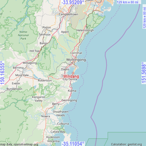
Windang GPS coordinates[2]
34° 31' 59.988" South, 150° 52' 0.012" East
| Map corner | latitude | longitude |
|---|---|---|
| Upper-left | -33.95209°, | 150.16355° |
| Center: | -34.53333°, | 150.86667° |
| Lower-right: | -35.11054°, | 151.5698° |
| Map W x H: | 128.8×128.8 km | = 80×80mi |
| max Lat: | -10.58257° ⇑63.5% North |
| Windang: | -34.53333° |
| min Lat: | ⇓36.5% South -43.31423° |
| min Long | Windang | max Long |
| 113.53327° | 150.86667° | 153.61246° |
| W 64.4%⇐ | ⇒35.6% E |
Elevation
Elevation of Windang is 3 m = 10 ft, and this is 119 m = 390 ft below average elevation for this country.
| Max E: |
1715 m = 5627 ft | 98.8% |
| Avg. | 122 m = 400 ft | |
| Windang | 3 m = 10 ft | |
Min E: |
-2 m = -7 ft | 1.2% |
See also: Australia elevation on elevation.city.
Geographical zone
Windang is located in South temperate zone (between Tropic of Capricorn and the Antarctic Circle). Distance of this Southern Tropic circle is 1233.8 km =766.6 mi to North.| Distance of | km | miles | from Windang |
|---|---|---|---|
| Equator | 3839.7 | 2385.9 | to North |
| Tropic Capricorn | 1233.8 | 766.6 | to North |
| Antarctic Circle | 3561.4 | 2213 | to South |
| South Pole | 6167.3 | 3832.2 | to South |


Nearby cities:
15 places around Windang: (largest is in red/bold)
• Barrack Heights
3.6 km =2.2 mi,  194°
194°
• Barrack Point
3.3 km =2.1 mi,  173°
173°
• Berkeley
5.8 km =3.6 mi,  344°
344°
• Blackbutt
5 km =3.1 mi,  211°
211°
• Flinders
5.7 km =3.5 mi, 190°
• Koonawarra
6.4 km =4 mi,  303°
303°
• Lake Heights
5.4 km =3.4 mi,  359°
359°
• Lake Illawarra
1.7 km =1.1 mi, 212°
• Mount Warrigal
3.1 km =1.9 mi,  238°
238°
• Oak Flats
5.2 km =3.2 mi,  231°
231°
• Primbee
3.5 km =2.2 mi,  19°
19°
• Shell Cove
6.3 km =3.9 mi,  183°
183°
• Shellharbour
5.6 km =3.5 mi, 180°
• Warilla
2.2 km =1.4 mi,  200°
200°
• Warrawong
5.7 km =3.5 mi, 20°
Sources, notices
• [Note1] Compared only with cities in Australia existing in our database
• [Src1] Map data: © OpenStreetMap contributors (CC-BY-SA)
• [Src2] Other city data from geonames.org with taken over terms of usage.
• [Src3] Geographical zone / Annual Mean Temperature by Robert A. Rohde @ Wikipedia
