Cranbourne geodata
Cranbourne (Victoria) is a section of populated place; located in Australia in Australia/Melbourne (GMT+11) time zone. With population of 19,825 people, there are 172 cities with bigger population in this country. Compared to other cities in Australia, 92.9% of cities are located further ↑North; 61.7% of cities are located further →East and 61.2% of cities have lower elevation than Cranbourne. Note1


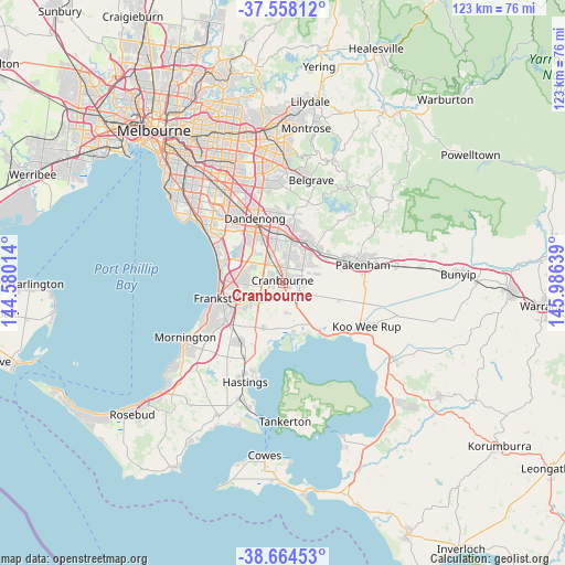
Cranbourne GPS coordinates[2]
38° 6' 48.312" South, 145° 16' 59.736" East
| Map corner | latitude | longitude |
|---|---|---|
| Upper-left | -37.55812°, | 144.58014° |
| Center: | -38.11342°, | 145.28326° |
| Lower-right: | -38.66453°, | 145.98639° |
| Map W x H: | 123×123 km | = 76.4×76.4mi |
| max Lat: | -10.58257° ⇑92.9% North |
| Cranbourne: | -38.11342° |
| min Lat: | ⇓7.1% South -43.31423° |
| min Long | Cranbourne | max Long |
| 113.53327° | 145.28326° | 153.61246° |
| W 38.3%⇐ | ⇒61.7% E |
Elevation
Elevation of Cranbourne is 67 m = 220 ft, and this is 55 m = 180 ft below average elevation for this country.
| Max E: |
1715 m = 5627 ft | 38.8% |
| Avg. | 122 m = 400 ft | |
| Cranbourne | 67 m = 220 ft | |
Min E: |
-2 m = -7 ft | 61.2% |
See also: Australia elevation on elevation.city.
Geographical zone
Cranbourne is located in South temperate zone (between Tropic of Capricorn and the Antarctic Circle). Distance of this Southern Tropic circle is 1631.9 km =1014 mi to North.| Distance of | km | miles | from Cranbourne |
|---|---|---|---|
| Equator | 4237.8 | 2633.2 | to North |
| Tropic Capricorn | 1631.9 | 1014 | to North |
| Antarctic Circle | 3163.4 | 1965.6 | to South |
| South Pole | 5769.2 | 3584.8 | to South |


Nearby cities:
15 places around Cranbourne: (largest is in red/bold)
• Botanic Ridge
3.1 km =1.9 mi,  204°
204°
• Clyde
4.9 km =3 mi,  116°
116°
• Clyde North
4.4 km =2.7 mi,  94°
94°
• Cranbourne East
1.3 km =0.8 mi,  99°
99°
• Cranbourne North
4.2 km =2.6 mi,  18°
18°
• Cranbourne South
4.5 km =2.8 mi,  237°
237°
• Cranbourne West
2.4 km =1.5 mi,  323°
323°
• Devon Meadows
6.1 km =3.8 mi,  166°
166°
• Hampton Park
9.4 km =5.8 mi,  341°
341°
• Junction Village
2.8 km =1.7 mi,  155°
155°
• Lynbrook
6.8 km =4.2 mi, 339°
• Narre Warren
9 km =5.6 mi,  9°
9°
• Narre Warren South
7.8 km =4.8 mi, 5°
• Sandhurst
7.5 km =4.7 mi,  298°
298°
• Skye
5.9 km =3.7 mi,  279°
279°
Sources, notices
• [Note1] Compared only with cities in Australia existing in our database
• [Src1] Map data: © OpenStreetMap contributors (CC-BY-SA)
• [Src2] Other city data from geonames.org with taken over terms of usage.
• [Src3] Geographical zone / Annual Mean Temperature by Robert A. Rohde @ Wikipedia
