Clyde geodata
Clyde (Victoria) is a section of populated place; located in Australia in Australia/Melbourne (GMT+11) time zone. With population of 2,090 people, there are 2835 cities with bigger population in this country. Compared to other cities in Australia, 93.2% of cities are located further ↑North; 61.2% of cities are located further →East and 55.9% of cities have higher elevation than Clyde. Note1


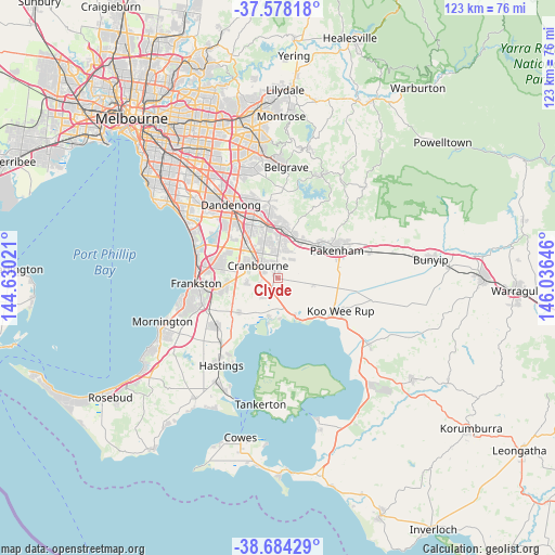
Clyde GPS coordinates[2]
38° 7' 59.988" South, 145° 19' 59.988" East
| Map corner | latitude | longitude |
|---|---|---|
| Upper-left | -37.57818°, | 144.63021° |
| Center: | -38.13333°, | 145.33333° |
| Lower-right: | -38.68429°, | 146.03646° |
| Map W x H: | 123×123 km | = 76.4×76.4mi |
| max Lat: | -10.58257° ⇑93.2% North |
| Clyde: | -38.13333° |
| min Lat: | ⇓6.8% South -43.31423° |
| min Long | Clyde | max Long |
| 113.53327° | 145.33333° | 153.61246° |
| W 38.8%⇐ | ⇒61.2% E |
Elevation
Elevation of Clyde is 37 m = 121 ft, and this is 85 m = 279 ft below average elevation for this country.
| Max E: |
1715 m = 5627 ft | 55.9% |
| Avg. | 122 m = 400 ft | |
| Clyde | 37 m = 121 ft | |
Min E: |
-2 m = -7 ft | 44.1% |
See also: Australia elevation on elevation.city.
Geographical zone
Clyde is located in South temperate zone (between Tropic of Capricorn and the Antarctic Circle). Distance of this Southern Tropic circle is 1634.1 km =1015.4 mi to North.| Distance of | km | miles | from Clyde |
|---|---|---|---|
| Equator | 4240 | 2634.6 | to North |
| Tropic Capricorn | 1634.1 | 1015.4 | to North |
| Antarctic Circle | 3161.1 | 1964.2 | to South |
| South Pole | 5767 | 3583.4 | to South |


Nearby cities:
15 places around Clyde: (largest is in red/bold)
• Beaconsfield
9.7 km =6 mi,  17°
17°
• Blind Bight
9 km =5.6 mi,  177°
177°
• Botanic Ridge
5.7 km =3.5 mi,  263°
263°
• Cannons Creek
8.9 km =5.5 mi,  190°
190°
• Clyde North
1.9 km =1.2 mi,  0°
0°
• Cranbourne
4.9 km =3 mi,  296°
296°
• Cranbourne East
3.7 km =2.3 mi, 303°
• Cranbourne North
6.9 km =4.3 mi,  333°
333°
• Cranbourne South
8.2 km =5.1 mi,  268°
268°
• Cranbourne West
7.1 km =4.4 mi,  305°
305°
• Devon Meadows
4.7 km =2.9 mi,  218°
218°
• Junction Village
3.2 km =2 mi, 263°
• Officer
10.6 km =6.6 mi,  38°
38°
• Tooradin
10 km =6.2 mi,  154°
154°
• Warneet
10.3 km =6.4 mi, 191°
Sources, notices
• [Note1] Compared only with cities in Australia existing in our database
• [Src1] Map data: © OpenStreetMap contributors (CC-BY-SA)
• [Src2] Other city data from geonames.org with taken over terms of usage.
• [Src3] Geographical zone / Annual Mean Temperature by Robert A. Rohde @ Wikipedia
