Coolangatta geodata
Coolangatta (Queensland) is a section of populated place; located in Australia in Australia/Brisbane (GMT+10) time zone. With population of 8,245 people, there are 794 cities with bigger population in this country. Compared to other cities in Australia, 75.3% of cities are located further ↓South; 99.5% of cities are located further ←West and 86.8% of cities have higher elevation than Coolangatta. Note1


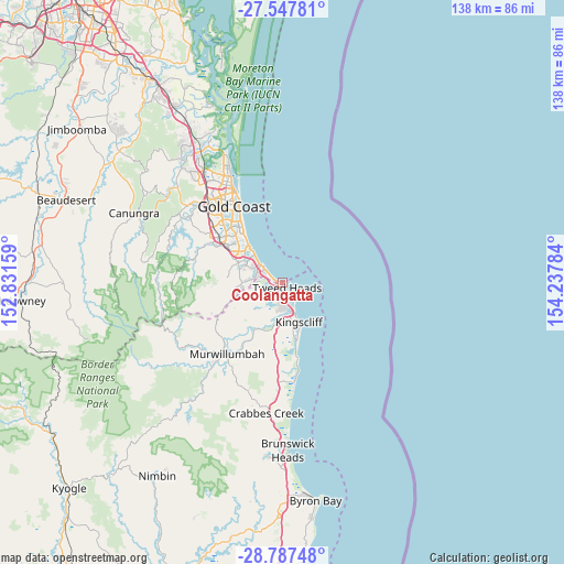
Coolangatta GPS coordinates[2]
28° 10' 9.984" South, 153° 32' 4.956" East
| Map corner | latitude | longitude |
|---|---|---|
| Upper-left | -27.54781°, | 152.83159° |
| Center: | -28.16944°, | 153.53471° |
| Lower-right: | -28.78748°, | 154.23784° |
| Map W x H: | 137.8×137.8 km | = 85.6×85.6mi |
| max Lat: | -10.58257° ⇑24.7% North |
| Coolangatta: | -28.16944° |
| min Lat: | ⇓75.3% South -43.31423° |
| min Long | Coolangatta | max Long |
| 113.53327° | 153.53471° | 153.61246° |
| W 99.5%⇐ | ⇒0.5% E |
Elevation
Elevation of Coolangatta is 11 m = 36 ft, and this is 111 m = 364 ft below average elevation for this country.
| Max E: |
1715 m = 5627 ft | 86.8% |
| Avg. | 122 m = 400 ft | |
| Coolangatta | 11 m = 36 ft | |
Min E: |
-2 m = -7 ft | 13.2% |
See also: Australia elevation on elevation.city.
Geographical zone
Coolangatta is located in South temperate zone (between Tropic of Capricorn and the Antarctic Circle). Distance of this Southern Tropic circle is 526.2 km =327 mi to North.| Distance of | km | miles | from Coolangatta |
|---|---|---|---|
| Equator | 3132.1 | 1946.2 | to North |
| Tropic Capricorn | 526.2 | 327 | to North |
| Antarctic Circle | 4269 | 2652.6 | to South |
| South Pole | 6874.9 | 4271.9 | to South |


Nearby cities:
15 places around Coolangatta: (largest is in red/bold)
• Banora Point
4.8 km =3 mi,  178°
178°
• Bilambil Heights
7.2 km =4.5 mi,  223°
223°
• Bilinga
1.8 km =1.1 mi,  279°
279°
• Chinderah
9.5 km =5.9 mi, 178°
• Currumbin
6.4 km =4 mi,  305°
305°
• Currumbin Waters
6.3 km =3.9 mi,  285°
285°
• Elanora
9.2 km =5.7 mi, 294°
• Fingal Head
4.7 km =2.9 mi,  140°
140°
• Palm Beach
8.9 km =5.5 mi, 310°
• Tallebudgera
10.2 km =6.3 mi, 282°
• Terranora
8.3 km =5.2 mi,  203°
203°
• Tugun
4 km =2.5 mi,  302°
302°
• Tweed Heads
1.3 km =0.8 mi,  128°
128°
• Tweed Heads South
2.9 km =1.8 mi,  170°
170°
• Tweed Heads West
2.3 km =1.4 mi,  210°
210°
Sources, notices
• [Note1] Compared only with cities in Australia existing in our database
• [Src1] Map data: © OpenStreetMap contributors (CC-BY-SA)
• [Src2] Other city data from geonames.org with taken over terms of usage.
• [Src3] Geographical zone / Annual Mean Temperature by Robert A. Rohde @ Wikipedia
