Chinderah geodata
Chinderah (New South Wales) is a section of populated place; located in Australia in Australia/Sydney (GMT+11) time zone. With population of 1,683 people, there are 3115 cities with bigger population in this country. Compared to other cities in Australia, 75% of cities are located further ↓South; 99.6% of cities are located further ←West and 96.8% of cities have higher elevation than Chinderah. Note1


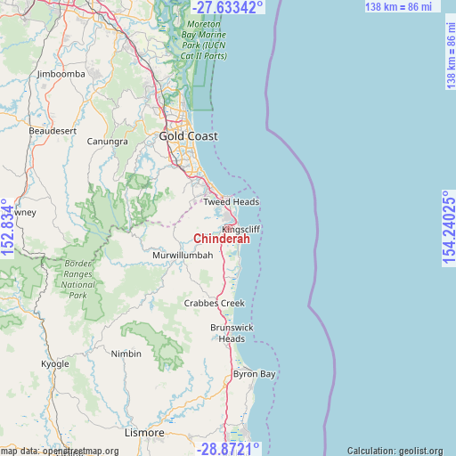
Chinderah GPS coordinates[2]
28° 15' 16.416" South, 153° 32' 13.632" East
| Map corner | latitude | longitude |
|---|---|---|
| Upper-left | -27.63342°, | 152.834° |
| Center: | -28.25456°, | 153.53712° |
| Lower-right: | -28.8721°, | 154.24025° |
| Map W x H: | 137.7×137.7 km | = 85.6×85.6mi |
| max Lat: | -10.58257° ⇑25% North |
| Chinderah: | -28.25456° |
| min Lat: | ⇓75% South -43.31423° |
| min Long | Chinderah | max Long |
| 113.53327° | 153.53712° | 153.61246° |
| W 99.6%⇐ | ⇒0.40000000000001% E |
Elevation
Elevation of Chinderah is 5 m = 16 ft, and this is 117 m = 384 ft below average elevation for this country.
| Max E: |
1715 m = 5627 ft | 96.8% |
| Avg. | 122 m = 400 ft | |
| Chinderah | 5 m = 16 ft | |
Min E: |
-2 m = -7 ft | 3.2% |
See also: Australia elevation on elevation.city.
Geographical zone
Chinderah is located in South temperate zone (between Tropic of Capricorn and the Antarctic Circle). Distance of this Southern Tropic circle is 535.7 km =332.9 mi to North.| Distance of | km | miles | from Chinderah |
|---|---|---|---|
| Equator | 3141.6 | 1952.1 | to North |
| Tropic Capricorn | 535.7 | 332.9 | to North |
| Antarctic Circle | 4259.6 | 2646.8 | to South |
| South Pole | 6865.4 | 4266 | to South |


Nearby cities:
15 places around Chinderah: (largest is in red/bold)
• Banora Point
4.6 km =2.9 mi,  359°
359°
• Bilambil Heights
6.7 km =4.2 mi,  309°
309°
• Bilinga
10 km =6.2 mi,  348°
348°
• Bogangar
8.9 km =5.5 mi,  159°
159°
• Casuarina
6.1 km =3.8 mi,  147°
147°
• Coolangatta
9.5 km =5.9 mi, 358°
• Cudgen
1.8 km =1.1 mi,  136°
136°
• Fingal Head
6.5 km =4 mi,  25°
25°
• Kingscliff
4.1 km =2.5 mi,  98°
98°
• Nunderi
10.7 km =6.6 mi,  225°
225°
• Terranora
4 km =2.5 mi,  296°
296°
• Tugun
12.2 km =7.6 mi,  342°
342°
• Tweed Heads
8.7 km =5.4 mi,  5°
5°
• Tweed Heads South
6.6 km =4.1 mi,  2°
2°
• Tweed Heads West
7.6 km =4.7 mi, 349°
Sources, notices
• [Note1] Compared only with cities in Australia existing in our database
• [Src1] Map data: © OpenStreetMap contributors (CC-BY-SA)
• [Src2] Other city data from geonames.org with taken over terms of usage.
• [Src3] Geographical zone / Annual Mean Temperature by Robert A. Rohde @ Wikipedia
