Cobbitty geodata
Cobbitty (New South Wales) is a section of populated place; located in Australia in Australia/Sydney (GMT+11) time zone. With population of 2,030 people, there are 2881 cities with bigger population in this country. Compared to other cities in Australia, 59.3% of cities are located further ↑North; 60.5% of cities are located further ←West and 70.4% of cities have lower elevation than Cobbitty. Note1


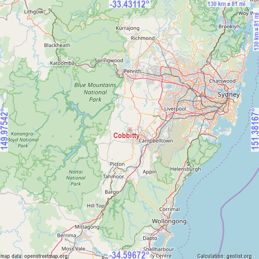
Cobbitty GPS coordinates[2]
34° 0' 57.312" South, 150° 40' 42.744" East
| Map corner | latitude | longitude |
|---|---|---|
| Upper-left | -33.43112°, | 149.97542° |
| Center: | -34.01592°, | 150.67854° |
| Lower-right: | -34.59672°, | 151.38167° |
| Map W x H: | 129.6×129.6 km | = 80.5×80.5mi |
| max Lat: | -10.58257° ⇑59.3% North |
| Cobbitty: | -34.01592° |
| min Lat: | ⇓40.7% South -43.31423° |
| min Long | Cobbitty | max Long |
| 113.53327° | 150.67854° | 153.61246° |
| W 60.5%⇐ | ⇒39.5% E |
Elevation
Elevation of Cobbitty is 105 m = 344 ft, and this is 17 m = 56 ft below average elevation for this country.
| Max E: |
1715 m = 5627 ft | 29.6% |
| Avg. | 122 m = 400 ft | |
| Cobbitty | 105 m = 344 ft | |
Min E: |
-2 m = -7 ft | 70.4% |
See also: Australia elevation on elevation.city.
Geographical zone
Cobbitty is located in South temperate zone (between Tropic of Capricorn and the Antarctic Circle). Distance of this Southern Tropic circle is 1176.3 km =730.9 mi to North.| Distance of | km | miles | from Cobbitty |
|---|---|---|---|
| Equator | 3782.2 | 2350.1 | to North |
| Tropic Capricorn | 1176.3 | 730.9 | to North |
| Antarctic Circle | 3619 | 2248.7 | to South |
| South Pole | 6224.8 | 3867.9 | to South |


Nearby cities:
15 places around Cobbitty: (largest is in red/bold)
• Camden
4.5 km =2.8 mi,  158°
158°
• Camden South
7.6 km =4.7 mi,  168°
168°
• Elderslie
5.4 km =3.4 mi,  143°
143°
• Ellis Lane
1.9 km =1.2 mi,  180°
180°
• Grasmere
4.4 km =2.7 mi,  195°
195°
• Harrington Park
5.3 km =3.3 mi,  99°
99°
• Kirkham
3.9 km =2.4 mi,  130°
130°
• Mount Annan
8.5 km =5.3 mi,  118°
118°
• Mount Hunter
7.2 km =4.5 mi,  211°
211°
• Narellan
5.8 km =3.6 mi, 121°
• Narellan Vale
7.1 km =4.4 mi, 121°
• Oran Park
5.8 km =3.6 mi,  78°
78°
• Orangeville
7.3 km =4.5 mi,  256°
256°
• Spring Farm
6.6 km =4.1 mi,  152°
152°
• Theresa Park
4.2 km =2.6 mi,  284°
284°
Sources, notices
• [Note1] Compared only with cities in Australia existing in our database
• [Src1] Map data: © OpenStreetMap contributors (CC-BY-SA)
• [Src2] Other city data from geonames.org with taken over terms of usage.
• [Src3] Geographical zone / Annual Mean Temperature by Robert A. Rohde @ Wikipedia
