Orangeville geodata
Orangeville (New South Wales) is a section of populated place; located in Australia in Australia/Sydney (GMT+11) time zone. With population of 1,236 people, there are 3534 cities with bigger population in this country. Compared to other cities in Australia, 59.6% of cities are located further ↑North; 59.7% of cities are located further ←West and 81.4% of cities have lower elevation than Orangeville. Note1


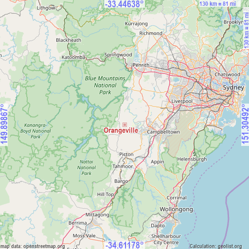
Orangeville GPS coordinates[2]
34° 1' 51.888" South, 150° 36' 6.444" East
| Map corner | latitude | longitude |
|---|---|---|
| Upper-left | -33.44638°, | 149.89867° |
| Center: | -34.03108°, | 150.60179° |
| Lower-right: | -34.61178°, | 151.30492° |
| Map W x H: | 129.6×129.6 km | = 80.5×80.5mi |
| max Lat: | -10.58257° ⇑59.6% North |
| Orangeville: | -34.03108° |
| min Lat: | ⇓40.4% South -43.31423° |
| min Long | Orangeville | max Long |
| 113.53327° | 150.60179° | 153.61246° |
| W 59.7%⇐ | ⇒40.3% E |
Elevation
Elevation of Orangeville is 196 m = 643 ft, and this is 74 m = 243 ft above average elevation for this country.
| Max E: |
1715 m = 5627 ft | 18.6% |
| Orangeville | 196 m 643 ft | |
| Avg. | 122 m = 400 ft | |
Min E: |
-2 m = -7 ft | 81.4% |
See also: Australia elevation on elevation.city.
Geographical zone
Orangeville is located in South temperate zone (between Tropic of Capricorn and the Antarctic Circle). Distance of this Southern Tropic circle is 1178 km =732 mi to North.| Distance of | km | miles | from Orangeville |
|---|---|---|---|
| Equator | 3783.9 | 2351.2 | to North |
| Tropic Capricorn | 1178 | 732 | to North |
| Antarctic Circle | 3617.3 | 2247.7 | to South |
| South Pole | 6223.2 | 3866.9 | to South |


Nearby cities:
15 places around Orangeville: (largest is in red/bold)
• Belimbla Park
8.2 km =5.1 mi,  224°
224°
• Camden
9.1 km =5.7 mi,  106°
106°
• Camden South
10.3 km =6.4 mi,  124°
124°
• Cobbitty
7.3 km =4.5 mi,  76°
76°
• Elderslie
10.7 km =6.6 mi,  104°
104°
• Ellis Lane
7 km =4.3 mi,  91°
91°
• Grasmere
6.4 km =4 mi, 113°
• Kirkham
10.1 km =6.3 mi, 94°
• Mount Hunter
5.6 km =3.5 mi,  143°
143°
• Narellan
12.1 km =7.5 mi, 96°
• Oakdale
9.8 km =6.1 mi,  236°
236°
• Spring Farm
11 km =6.8 mi, 112°
• The Oaks
6.2 km =3.9 mi,  208°
208°
• Theresa Park
4.1 km =2.5 mi,  48°
48°
• Werombi
5.6 km =3.5 mi,  342°
342°
Sources, notices
• [Note1] Compared only with cities in Australia existing in our database
• [Src1] Map data: © OpenStreetMap contributors (CC-BY-SA)
• [Src2] Other city data from geonames.org with taken over terms of usage.
• [Src3] Geographical zone / Annual Mean Temperature by Robert A. Rohde @ Wikipedia
