Clareville geodata
Clareville (New South Wales) is a populated place; located in Australia in Australia/Sydney (GMT+11) time zone. With population of 726 people, there are 4285 cities with bigger population in this country. Compared to other cities in Australia, 52.3% of cities are located further ↓South; 76% of cities are located further ←West and 53.5% of cities have lower elevation than Clareville. Note1


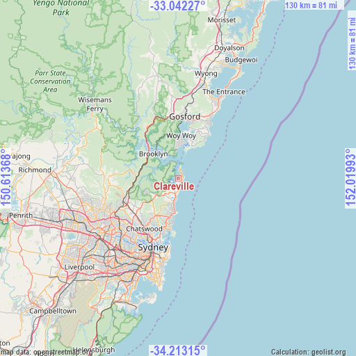
Clareville GPS coordinates[2]
33° 37' 46.92" South, 151° 19' 0.48" East
| Map corner | latitude | longitude |
|---|---|---|
| Upper-left | -33.04227°, | 150.61368° |
| Center: | -33.6297°, | 151.3168° |
| Lower-right: | -34.21315°, | 152.01993° |
| Map W x H: | 130.2×130.2 km | = 80.9×80.9mi |
| max Lat: | -10.58257° ⇑47.7% North |
| Clareville: | -33.6297° |
| min Lat: | ⇓52.3% South -43.31423° |
| min Long | Clareville | max Long |
| 113.53327° | 151.3168° | 153.61246° |
| W 76%⇐ | ⇒24% E |
Elevation
Elevation of Clareville is 50 m = 164 ft, and this is 72 m = 236 ft below average elevation for this country.
| Max E: |
1715 m = 5627 ft | 46.5% |
| Avg. | 122 m = 400 ft | |
| Clareville | 50 m = 164 ft | |
Min E: |
-2 m = -7 ft | 53.5% |
See also: Australia elevation on elevation.city.
Geographical zone
Clareville is located in South temperate zone (between Tropic of Capricorn and the Antarctic Circle). Distance of this Southern Tropic circle is 1133.4 km =704.3 mi to North.| Distance of | km | miles | from Clareville |
|---|---|---|---|
| Equator | 3739.3 | 2323.5 | to North |
| Tropic Capricorn | 1133.4 | 704.3 | to North |
| Antarctic Circle | 3661.9 | 2275.4 | to South |
| South Pole | 6267.8 | 3894.6 | to South |


Nearby cities:
15 places around Clareville: (largest is in red/bold)
• Bay View
3.7 km =2.3 mi,  206°
206°
• Bilgola Plateau
2.1 km =1.3 mi,  192°
192°
• Church Point
3.5 km =2.2 mi,  240°
240°
• Collaroy Plateau
11.3 km =7 mi, 192°
• Elanora Heights
8.7 km =5.4 mi,  203°
203°
• Ingleside
7.8 km =4.8 mi,  218°
218°
• Mona Vale
5.5 km =3.4 mi, 193°
• Narrabeen
9.4 km =5.8 mi, 191°
• Newport
3 km =1.9 mi,  184°
184°
• North Narrabeen
9.1 km =5.7 mi, 192°
• Palm Beach
3.7 km =2.3 mi,  10°
10°
• Pearl Beach
9.6 km =6 mi,  352°
352°
• Scotland Island
3 km =1.9 mi,  245°
245°
• Terry Hills
9.8 km =6.1 mi,  232°
232°
• Warriewood
6.8 km =4.2 mi, 196°
Sources, notices
• [Note1] Compared only with cities in Australia existing in our database
• [Src1] Map data: © OpenStreetMap contributors (CC-BY-SA)
• [Src2] Other city data from geonames.org with taken over terms of usage.
• [Src3] Geographical zone / Annual Mean Temperature by Robert A. Rohde @ Wikipedia
