Church Point geodata
Church Point (New South Wales) is a section of populated place; located in Australia in Australia/Sydney (GMT+11) time zone. With population of 968 people, there are 3870 cities with bigger population in this country. Compared to other cities in Australia, 52.2% of cities are located further ↓South; 75.5% of cities are located further ←West and 83.5% of cities have higher elevation than Church Point. Note1


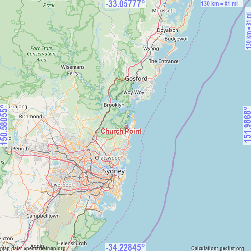
Church Point GPS coordinates[2]
33° 38' 42.36" South, 151° 17' 1.212" East
| Map corner | latitude | longitude |
|---|---|---|
| Upper-left | -33.05777°, | 150.58055° |
| Center: | -33.6451°, | 151.28367° |
| Lower-right: | -34.22845°, | 151.9868° |
| Map W x H: | 130.2×130.2 km | = 80.9×80.9mi |
| max Lat: | -10.58257° ⇑47.8% North |
| Church Point: | -33.6451° |
| min Lat: | ⇓52.2% South -43.31423° |
| min Long | Church Point | max Long |
| 113.53327° | 151.28367° | 153.61246° |
| W 75.5%⇐ | ⇒24.5% E |
Elevation
Elevation of Church Point is 13 m = 43 ft, and this is 109 m = 358 ft below average elevation for this country.
| Max E: |
1715 m = 5627 ft | 83.5% |
| Avg. | 122 m = 400 ft | |
| Church Point | 13 m = 43 ft | |
Min E: |
-2 m = -7 ft | 16.5% |
See also: Australia elevation on elevation.city.
Geographical zone
Church Point is located in South temperate zone (between Tropic of Capricorn and the Antarctic Circle). Distance of this Southern Tropic circle is 1135.1 km =705.3 mi to North.| Distance of | km | miles | from Church Point |
|---|---|---|---|
| Equator | 3741 | 2324.5 | to North |
| Tropic Capricorn | 1135.1 | 705.3 | to North |
| Antarctic Circle | 3660.2 | 2274.3 | to South |
| South Pole | 6266.1 | 3893.6 | to South |


Nearby cities:
15 places around Church Point: (largest is in red/bold)
• Bay View
2.2 km =1.4 mi,  139°
139°
• Bilgola Plateau
2.7 km =1.7 mi,  96°
96°
• Clareville
3.5 km =2.2 mi,  60°
60°
• Collaroy Plateau
9.3 km =5.8 mi,  175°
175°
• Elanora Heights
6.3 km =3.9 mi, 183°
• Ingleside
4.8 km =3 mi,  202°
202°
• Mona Vale
4 km =2.5 mi,  153°
153°
• Narrabeen
7.6 km =4.7 mi,  170°
170°
• Newport
3.1 km =1.9 mi,  114°
114°
• North Narrabeen
7.2 km =4.5 mi, 170°
• Palm Beach
6.5 km =4 mi,  34°
34°
• Scotland Island
0.6 km =0.4 mi,  35°
35°
• Terry Hills
6.3 km =3.9 mi,  227°
227°
• Warriewood
5 km =3.1 mi, 167°
• Wheeler Heights
9.6 km =6 mi, 181°
Sources, notices
• [Note1] Compared only with cities in Australia existing in our database
• [Src1] Map data: © OpenStreetMap contributors (CC-BY-SA)
• [Src2] Other city data from geonames.org with taken over terms of usage.
• [Src3] Geographical zone / Annual Mean Temperature by Robert A. Rohde @ Wikipedia
