Cessnock geodata
Cessnock (New South Wales) is a populated place; located in Australia in Australia/Sydney (GMT+11) time zone. With population of 15,076 people, there are 272 cities with bigger population in this country. Compared to other cities in Australia, 59.5% of cities are located further ↓South; 76.5% of cities are located further ←West and 62.4% of cities have lower elevation than Cessnock. Note1


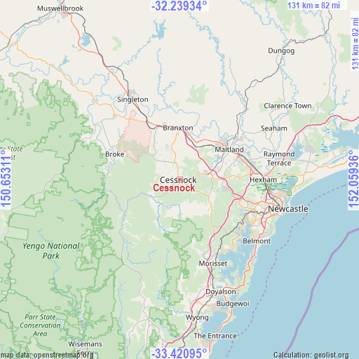
Cessnock GPS coordinates[2]
32° 49' 55.596" South, 151° 21' 22.428" East
| Map corner | latitude | longitude |
|---|---|---|
| Upper-left | -32.23934°, | 150.65311° |
| Center: | -32.83211°, | 151.35623° |
| Lower-right: | -33.42095°, | 152.05936° |
| Map W x H: | 131.4×131.4 km | = 81.6×81.6mi |
| max Lat: | -10.58257° ⇑40.5% North |
| Cessnock: | -32.83211° |
| min Lat: | ⇓59.5% South -43.31423° |
| min Long | Cessnock | max Long |
| 113.53327° | 151.35623° | 153.61246° |
| W 76.5%⇐ | ⇒23.5% E |
Elevation
Elevation of Cessnock is 71 m = 233 ft, and this is 51 m = 167 ft below average elevation for this country.
| Max E: |
1715 m = 5627 ft | 37.6% |
| Avg. | 122 m = 400 ft | |
| Cessnock | 71 m = 233 ft | |
Min E: |
-2 m = -7 ft | 62.4% |
See also: Australia elevation on elevation.city.
Geographical zone
Cessnock is located in South temperate zone (between Tropic of Capricorn and the Antarctic Circle). Distance of this Southern Tropic circle is 1044.7 km =649.1 mi to North.| Distance of | km | miles | from Cessnock |
|---|---|---|---|
| Equator | 3650.6 | 2268.4 | to North |
| Tropic Capricorn | 1044.7 | 649.1 | to North |
| Antarctic Circle | 3750.6 | 2330.5 | to South |
| South Pole | 6356.5 | 3949.7 | to South |


Nearby cities:
15 places around Cessnock: (largest is in red/bold)
• Aberdare
2.6 km =1.6 mi,  112°
112°
• Abermain
7.2 km =4.5 mi,  67°
67°
• Bellbird
4.7 km =2.9 mi,  228°
228°
• Bellbird Heights
3.3 km =2.1 mi, 231°
• Ellalong
10.1 km =6.3 mi,  204°
204°
• Kearsley
4.7 km =2.9 mi,  121°
121°
• Kurri Kurri
11.6 km =7.2 mi,  82°
82°
• Lovedale
6.9 km =4.3 mi,  6°
6°
• Millfield
10.9 km =6.8 mi, 234°
• Mulbring
14.5 km =9 mi, 123°
• Nulkaba
2.5 km =1.6 mi,  342°
342°
• Paxton
10.6 km =6.6 mi,  218°
218°
• Pelaw Main
11.7 km =7.3 mi,  93°
93°
• Pokolbin
7.7 km =4.8 mi,  297°
297°
• Stanford Merthyr
12.9 km =8 mi, 86°
Sources, notices
• [Note1] Compared only with cities in Australia existing in our database
• [Src1] Map data: © OpenStreetMap contributors (CC-BY-SA)
• [Src2] Other city data from geonames.org with taken over terms of usage.
• [Src3] Geographical zone / Annual Mean Temperature by Robert A. Rohde @ Wikipedia
