Aberdare geodata
Aberdare (New South Wales) is a section of populated place; located in Australia in Australia/Sydney (GMT+11) time zone. With population of 2,419 people, there are 2620 cities with bigger population in this country. Compared to other cities in Australia, 59.4% of cities are located further ↓South; 76.8% of cities are located further ←West and 67.8% of cities have lower elevation than Aberdare. Note1


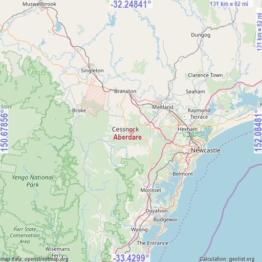
Aberdare GPS coordinates[2]
32° 50' 28.032" South, 151° 22' 54.048" East
| Map corner | latitude | longitude |
|---|---|---|
| Upper-left | -32.24841°, | 150.67856° |
| Center: | -32.84112°, | 151.38168° |
| Lower-right: | -33.4299°, | 152.08481° |
| Map W x H: | 131.4×131.4 km | = 81.6×81.6mi |
| max Lat: | -10.58257° ⇑40.6% North |
| Aberdare: | -32.84112° |
| min Lat: | ⇓59.4% South -43.31423° |
| min Long | Aberdare | max Long |
| 113.53327° | 151.38168° | 153.61246° |
| W 76.8%⇐ | ⇒23.2% E |
Elevation
Elevation of Aberdare is 92 m = 302 ft, and this is 30 m = 98 ft below average elevation for this country.
| Max E: |
1715 m = 5627 ft | 32.2% |
| Avg. | 122 m = 400 ft | |
| Aberdare | 92 m = 302 ft | |
Min E: |
-2 m = -7 ft | 67.8% |
See also: Australia elevation on elevation.city.
Geographical zone
Aberdare is located in South temperate zone (between Tropic of Capricorn and the Antarctic Circle). Distance of this Southern Tropic circle is 1045.7 km =649.8 mi to North.| Distance of | km | miles | from Aberdare |
|---|---|---|---|
| Equator | 3651.6 | 2269 | to North |
| Tropic Capricorn | 1045.7 | 649.8 | to North |
| Antarctic Circle | 3749.6 | 2329.9 | to South |
| South Pole | 6355.5 | 3949.1 | to South |


Nearby cities:
15 places around Aberdare: (largest is in red/bold)
• Abermain
5.7 km =3.5 mi,  48°
48°
• Bellbird
6.2 km =3.9 mi,  250°
250°
• Bellbird Heights
5 km =3.1 mi,  258°
258°
• Cessnock
2.6 km =1.6 mi,  292°
292°
• Ellalong
10.5 km =6.5 mi,  218°
218°
• Kearsley
2.2 km =1.4 mi,  131°
131°
• Kurri Kurri
9.4 km =5.8 mi,  75°
75°
• Lovedale
8 km =5 mi,  348°
348°
• Millfield
12.4 km =7.7 mi,  244°
244°
• Mulbring
12 km =7.5 mi, 126°
• Nulkaba
4.6 km =2.9 mi,  317°
317°
• Paxton
11.6 km =7.2 mi,  231°
231°
• Pelaw Main
9.3 km =5.8 mi,  87°
87°
• Pokolbin
10.3 km =6.4 mi,  296°
296°
• Stanford Merthyr
10.6 km =6.6 mi, 80°
Sources, notices
• [Note1] Compared only with cities in Australia existing in our database
• [Src1] Map data: © OpenStreetMap contributors (CC-BY-SA)
• [Src2] Other city data from geonames.org with taken over terms of usage.
• [Src3] Geographical zone / Annual Mean Temperature by Robert A. Rohde @ Wikipedia
