Rydalmere geodata
Rydalmere (New South Wales) is a section of populated place; located in Australia in Australia/Sydney (GMT+11) time zone. With population of 6,571 people, there are 1056 cities with bigger population in this country. Compared to other cities in Australia, 52.3% of cities are located further ↑North; 68.3% of cities are located further ←West and 85% of cities have higher elevation than Rydalmere. Note1


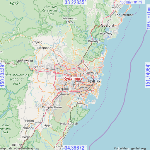
Rydalmere GPS coordinates[2]
33° 48' 52.308" South, 151° 2' 15.036" East
| Map corner | latitude | longitude |
|---|---|---|
| Upper-left | -33.22835°, | 150.33439° |
| Center: | -33.81453°, | 151.03751° |
| Lower-right: | -34.39672°, | 151.74064° |
| Map W x H: | 129.9×129.9 km | = 80.7×80.7mi |
| max Lat: | -10.58257° ⇑52.3% North |
| Rydalmere: | -33.81453° |
| min Lat: | ⇓47.7% South -43.31423° |
| min Long | Rydalmere | max Long |
| 113.53327° | 151.03751° | 153.61246° |
| W 68.3%⇐ | ⇒31.7% E |
Elevation
Elevation of Rydalmere is 12 m = 39 ft, and this is 110 m = 361 ft below average elevation for this country.
| Max E: |
1715 m = 5627 ft | 85% |
| Avg. | 122 m = 400 ft | |
| Rydalmere | 12 m = 39 ft | |
Min E: |
-2 m = -7 ft | 15% |
See also: Australia elevation on elevation.city.
Geographical zone
Rydalmere is located in South temperate zone (between Tropic of Capricorn and the Antarctic Circle). Distance of this Southern Tropic circle is 1153.9 km =717 mi to North.| Distance of | km | miles | from Rydalmere |
|---|---|---|---|
| Equator | 3759.8 | 2336.2 | to North |
| Tropic Capricorn | 1153.9 | 717 | to North |
| Antarctic Circle | 3641.4 | 2262.7 | to South |
| South Pole | 6247.2 | 3881.8 | to South |


Nearby cities:
15 places around Rydalmere: (largest is in red/bold)
• Auburn
4 km =2.5 mi,  185°
185°
• Carlingford
3.7 km =2.3 mi,  16°
16°
• Denistone West
3.9 km =2.4 mi,  66°
66°
• Dundas Valley
3.2 km =2 mi,  25°
25°
• Ermington
1.6 km =1 mi,  91°
91°
• Harris Park
2.9 km =1.8 mi,  251°
251°
• Melrose Park
3.2 km =2 mi, 90°
• Newington
2.9 km =1.8 mi,  141°
141°
• Oatlands
2.3 km =1.4 mi,  335°
335°
• Parramatta
3.2 km =2 mi,  263°
263°
• Rosehill
1.4 km =0.9 mi,  242°
242°
• Silverwater
2.3 km =1.4 mi,  156°
156°
• Telopea
2.4 km =1.5 mi,  2°
2°
• Wentworth Point
3.9 km =2.4 mi,  117°
117°
• West Ryde
3.5 km =2.2 mi, 73°
Sources, notices
• [Note1] Compared only with cities in Australia existing in our database
• [Src1] Map data: © OpenStreetMap contributors (CC-BY-SA)
• [Src2] Other city data from geonames.org with taken over terms of usage.
• [Src3] Geographical zone / Annual Mean Temperature by Robert A. Rohde @ Wikipedia
