Buccan geodata
Buccan (Queensland) is a section of populated place; located in Australia in Australia/Brisbane (GMT+10) time zone. With population of 1,764 people, there are 3075 cities with bigger population in this country. Compared to other cities in Australia, 77.3% of cities are located further ↓South; 95.7% of cities are located further ←West and 67.2% of cities have higher elevation than Buccan. Note1


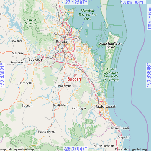
Buccan GPS coordinates[2]
27° 45' 0" South, 153° 7' 59.988" East
| Map corner | latitude | longitude |
|---|---|---|
| Upper-left | -27.12597°, | 152.43021° |
| Center: | -27.75°, | 153.13333° |
| Lower-right: | -28.37047°, | 153.83646° |
| Map W x H: | 138.4×138.4 km | = 86×86mi |
| max Lat: | -10.58257° ⇑22.7% North |
| Buccan: | -27.75° |
| min Lat: | ⇓77.3% South -43.31423° |
| min Long | Buccan | max Long |
| 113.53327° | 153.13333° | 153.61246° |
| W 95.7%⇐ | ⇒4.3% E |
Elevation
Elevation of Buccan is 25 m = 82 ft, and this is 97 m = 318 ft below average elevation for this country.
| Max E: |
1715 m = 5627 ft | 67.2% |
| Avg. | 122 m = 400 ft | |
| Buccan | 25 m = 82 ft | |
Min E: |
-2 m = -7 ft | 32.8% |
See also: Australia elevation on elevation.city.
Geographical zone
Buccan is located in South temperate zone (between Tropic of Capricorn and the Antarctic Circle). Distance of this Southern Tropic circle is 479.6 km =298 mi to North.| Distance of | km | miles | from Buccan |
|---|---|---|---|
| Equator | 3085.5 | 1917.2 | to North |
| Tropic Capricorn | 479.6 | 298 | to North |
| Antarctic Circle | 4315.7 | 2681.7 | to South |
| South Pole | 6921.6 | 4300.9 | to South |


Nearby cities:
15 places around Buccan: (largest is in red/bold)
• Bahrs Scrub
3.8 km =2.4 mi,  60°
60°
• Bannockburn
5.9 km =3.7 mi,  100°
100°
• Beenleigh
8.1 km =5 mi, 57°
• Chambers Flat
5.5 km =3.4 mi,  272°
272°
• Crestmead
8.4 km =5.2 mi,  325°
325°
• Edens Landing
6.3 km =3.9 mi,  34°
34°
• Holmview
5.2 km =3.2 mi,  44°
44°
• Logan Reserve
5.1 km =3.2 mi,  304°
304°
• Logan Village
3.2 km =2 mi,  231°
231°
• Loganlea
8.3 km =5.2 mi,  0°
0°
• Mount Warren Park
7.4 km =4.6 mi,  73°
73°
• Stockleigh
6.8 km =4.2 mi,  254°
254°
• Waterford West
6.6 km =4.1 mi,  359°
359°
• Windaroo
5.9 km =3.7 mi,  85°
85°
• Yarrabilba
6.9 km =4.3 mi,  198°
198°
Sources, notices
• [Note1] Compared only with cities in Australia existing in our database
• [Src1] Map data: © OpenStreetMap contributors (CC-BY-SA)
• [Src2] Other city data from geonames.org with taken over terms of usage.
• [Src3] Geographical zone / Annual Mean Temperature by Robert A. Rohde @ Wikipedia
