Yarrabilba geodata
Yarrabilba (Queensland) is a section of populated place; located in Australia in Australia/Brisbane (GMT+10) time zone. With population of 3,608 people, there are 1954 cities with bigger population in this country. Compared to other cities in Australia, 77.1% of cities are located further ↓South; 95.2% of cities are located further ←West and 72.5% of cities have lower elevation than Yarrabilba. Note1


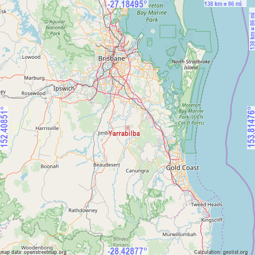
Yarrabilba GPS coordinates[2]
27° 48' 31.104" South, 153° 6' 41.868" East
| Map corner | latitude | longitude |
|---|---|---|
| Upper-left | -27.18495°, | 152.40851° |
| Center: | -27.80864°, | 153.11163° |
| Lower-right: | -28.42877°, | 153.81476° |
| Map W x H: | 138.3×138.3 km | = 85.9×85.9mi |
| max Lat: | -10.58257° ⇑22.9% North |
| Yarrabilba: | -27.80864° |
| min Lat: | ⇓77.1% South -43.31423° |
| min Long | Yarrabilba | max Long |
| 113.53327° | 153.11163° | 153.61246° |
| W 95.2%⇐ | ⇒4.8% E |
Elevation
Elevation of Yarrabilba is 115 m = 377 ft, and this is 7 m = 23 ft below average elevation for this country.
| Max E: |
1715 m = 5627 ft | 27.5% |
| Avg. | 122 m = 400 ft | |
| Yarrabilba | 115 m = 377 ft | |
Min E: |
-2 m = -7 ft | 72.5% |
See also: Australia elevation on elevation.city.
Geographical zone
Yarrabilba is located in South temperate zone (between Tropic of Capricorn and the Antarctic Circle). Distance of this Southern Tropic circle is 486.1 km =302 mi to North.| Distance of | km | miles | from Yarrabilba |
|---|---|---|---|
| Equator | 3092 | 1921.3 | to North |
| Tropic Capricorn | 486.1 | 302 | to North |
| Antarctic Circle | 4309.1 | 2677.5 | to South |
| South Pole | 6915 | 4296.8 | to South |


Nearby cities:
15 places around Yarrabilba: (largest is in red/bold)
• Bahrs Scrub
10 km =6.2 mi,  32°
32°
• Bannockburn
9.6 km =6 mi,  55°
55°
• Buccan
6.9 km =4.3 mi,  18°
18°
• Cedar Creek
10.5 km =6.5 mi,  124°
124°
• Chambers Flat
7.5 km =4.7 mi,  333°
333°
• Jimboomba
8.7 km =5.4 mi,  253°
253°
• Logan Reserve
9.6 km =6 mi,  347°
347°
• Logan Village
4.5 km =2.8 mi, 354°
• Mundoolun
10.8 km =6.7 mi,  201°
201°
• Munruben
10.5 km =6.5 mi,  311°
311°
• North Maclean
10.4 km =6.5 mi,  295°
295°
• South Maclean
9.6 km =6 mi,  280°
280°
• Stockleigh
6.4 km =4 mi,  316°
316°
• Tamborine
8.6 km =5.3 mi,  165°
165°
• Windaroo
10.6 km =6.6 mi,  49°
49°
Sources, notices
• [Note1] Compared only with cities in Australia existing in our database
• [Src1] Map data: © OpenStreetMap contributors (CC-BY-SA)
• [Src2] Other city data from geonames.org with taken over terms of usage.
• [Src3] Geographical zone / Annual Mean Temperature by Robert A. Rohde @ Wikipedia
