Broughton geodata
Broughton (Queensland) is a populated place; located in Australia in Australia/Brisbane (GMT+10) time zone. With population of 678 people, there are 4368 cities with bigger population in this country. Compared to other cities in Australia, 94.4% of cities are located further ↓South; 55.5% of cities are located further →East and 84% of cities have lower elevation than Broughton. Note1


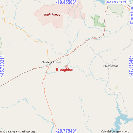
Broughton GPS coordinates[2]
20° 7' 0.012" South, 146° 25' 59.988" East
| Map corner | latitude | longitude |
|---|---|---|
| Upper-left | -19.45506°, | 145.73021° |
| Center: | -20.11667°, | 146.43333° |
| Lower-right: | -20.77549°, | 147.13646° |
| Map W x H: | 146.8×146.8 km | = 91.2×91.2mi |
| max Lat: | -10.58257° ⇑5.6% North |
| Broughton: | -20.11667° |
| min Lat: | ⇓94.4% South -43.31423° |
| min Long | Broughton | max Long |
| 113.53327° | 146.43333° | 153.61246° |
| W 44.5%⇐ | ⇒55.5% E |
Elevation
Elevation of Broughton is 230 m = 755 ft, and this is 108 m = 354 ft above average elevation for this country.
| Max E: |
1715 m = 5627 ft | 16% |
| Broughton | 230 m 755 ft | |
| Avg. | 122 m = 400 ft | |
Min E: |
-2 m = -7 ft | 84% |
See also: Australia elevation on elevation.city.
Geographical zone
Broughton is located in South Torrid zone (between Equator and Tropic of Capricorn). Distance of this Southern Tropic circle is 369.2 km =229.4 mi to South.| Distance of | km | miles | from Broughton |
|---|---|---|---|
| Equator | 2236.8 | 1389.9 | to North |
| Tropic Capricorn | 369.2 | 229.4 | to South |
| Antarctic Circle | 5164.4 | 3209 | to South |
| South Pole | 7770.3 | 4828.2 | to South |


Nearby cities:
15 places around Broughton: (largest is in red/bold)
• Alice River
89 km =55.3 mi,  12°
12°
• Bohle Plains
93.3 km =58 mi,  16°
16°
• Breddan
21.3 km =13.2 mi,  315°
315°
• Charters Towers
18.3 km =11.4 mi,  284°
284°
• Charters Towers City
18.3 km =11.4 mi, 283°
• Condon
92.4 km =57.4 mi, 18°
• Douglas
94.3 km =58.6 mi, 20°
• Kelso
86.2 km =53.6 mi, 20°
• Kirwan
95.5 km =59.3 mi, 18°
• Millchester
16.4 km =10.2 mi, 279°
• Queenton
16.5 km =10.3 mi,  286°
286°
• Rangewood
92.1 km =57.2 mi, 13°
• Rasmussen
90.2 km =56 mi, 19°
• Southern Cross
28.2 km =17.5 mi, 290°
• Toll
20.3 km =12.6 mi, 291°
Sources, notices
• [Note1] Compared only with cities in Australia existing in our database
• [Src1] Map data: © OpenStreetMap contributors (CC-BY-SA)
• [Src2] Other city data from geonames.org with taken over terms of usage.
• [Src3] Geographical zone / Annual Mean Temperature by Robert A. Rohde @ Wikipedia
