Millchester geodata
Millchester (Queensland) is a populated place; located in Australia in Australia/Brisbane (GMT+10) time zone. With population of 541 people, there are 4743 cities with bigger population in this country. Compared to other cities in Australia, 94.5% of cities are located further ↓South; 56.1% of cities are located further →East and 87.5% of cities have lower elevation than Millchester. Note1


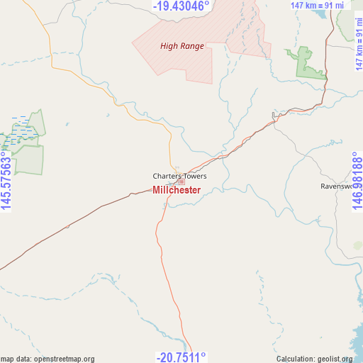
Millchester GPS coordinates[2]
20° 5' 31.812" South, 146° 16' 43.5" East
| Map corner | latitude | longitude |
|---|---|---|
| Upper-left | -19.43046°, | 145.57563° |
| Center: | -20.09217°, | 146.27875° |
| Lower-right: | -20.7511°, | 146.98188° |
| Map W x H: | 146.8×146.8 km | = 91.2×91.2mi |
| max Lat: | -10.58257° ⇑5.5% North |
| Millchester: | -20.09217° |
| min Lat: | ⇓94.5% South -43.31423° |
| min Long | Millchester | max Long |
| 113.53327° | 146.27875° | 153.61246° |
| W 43.9%⇐ | ⇒56.1% E |
Elevation
Elevation of Millchester is 300 m = 984 ft, and this is 178 m = 584 ft above average elevation for this country.
| Max E: |
1715 m = 5627 ft | 12.5% |
| Millchester | 300 m 984 ft | |
| Avg. | 122 m = 400 ft | |
Min E: |
-2 m = -7 ft | 87.5% |
See also: Australia elevation on elevation.city.
Geographical zone
Millchester is located in South Torrid zone (between Equator and Tropic of Capricorn). Distance of this Southern Tropic circle is 371.9 km =231.1 mi to South.| Distance of | km | miles | from Millchester |
|---|---|---|---|
| Equator | 2234 | 1388.1 | to North |
| Tropic Capricorn | 371.9 | 231.1 | to South |
| Antarctic Circle | 5167.1 | 3210.7 | to South |
| South Pole | 7773 | 4829.9 | to South |


Nearby cities:
15 places around Millchester: (largest is in red/bold)
• Alice River
91.3 km =56.7 mi,  22°
22°
• Bohle Plains
96.8 km =60.1 mi,  26°
26°
• Breddan
12.5 km =7.8 mi,  5°
5°
• Broughton
16.4 km =10.2 mi,  99°
99°
• Charters Towers
2.3 km =1.4 mi,  317°
317°
• Charters Towers City
2.3 km =1.4 mi,  313°
313°
• Condon
96.4 km =59.9 mi, 28°
• Douglas
98.8 km =61.4 mi, 30°
• Kelso
90.7 km =56.4 mi, 30°
• Kirwan
99.4 km =61.8 mi, 28°
• Queenton
2 km =1.2 mi, 8°
• Rangewood
94.6 km =58.8 mi, 23°
• Rasmussen
94.5 km =58.7 mi, 29°
• Southern Cross
12.6 km =7.8 mi, 305°
• Toll
5.4 km =3.4 mi,  329°
329°
Sources, notices
• [Note1] Compared only with cities in Australia existing in our database
• [Src1] Map data: © OpenStreetMap contributors (CC-BY-SA)
• [Src2] Other city data from geonames.org with taken over terms of usage.
• [Src3] Geographical zone / Annual Mean Temperature by Robert A. Rohde @ Wikipedia
