Broadmeadows geodata
Broadmeadows (Victoria) is a section of populated place; located in Australia in Australia/Melbourne (GMT+11) time zone. With population of 12,009 people, there are 412 cities with bigger population in this country. Compared to other cities in Australia, 84.4% of cities are located further ↑North; 67.7% of cities are located further →East and 74.3% of cities have lower elevation than Broadmeadows. Note1


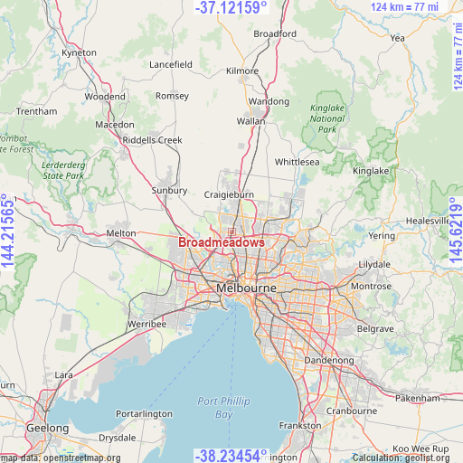
Broadmeadows GPS coordinates[2]
37° 40' 48.54" South, 144° 55' 7.572" East
| Map corner | latitude | longitude |
|---|---|---|
| Upper-left | -37.12159°, | 144.21565° |
| Center: | -37.68015°, | 144.91877° |
| Lower-right: | -38.23454°, | 145.6219° |
| Map W x H: | 123.7×123.7 km | = 76.9×76.9mi |
| max Lat: | -10.58257° ⇑84.4% North |
| Broadmeadows: | -37.68015° |
| min Lat: | ⇓15.6% South -43.31423° |
| min Long | Broadmeadows | max Long |
| 113.53327° | 144.91877° | 153.61246° |
| W 32.3%⇐ | ⇒67.7% E |
Elevation
Elevation of Broadmeadows is 125 m = 410 ft, and this is 3 m = 10 ft above average elevation for this country.
| Max E: |
1715 m = 5627 ft | 25.7% |
| Broadmeadows | 125 m 410 ft | |
| Avg. | 122 m = 400 ft | |
Min E: |
-2 m = -7 ft | 74.3% |
See also: Australia elevation on elevation.city.
Geographical zone
Broadmeadows is located in South temperate zone (between Tropic of Capricorn and the Antarctic Circle). Distance of this Southern Tropic circle is 1583.7 km =984.1 mi to North.| Distance of | km | miles | from Broadmeadows |
|---|---|---|---|
| Equator | 4189.6 | 2603.3 | to North |
| Tropic Capricorn | 1583.7 | 984.1 | to North |
| Antarctic Circle | 3211.5 | 1995.5 | to South |
| South Pole | 5817.4 | 3614.8 | to South |


Nearby cities:
15 places around Broadmeadows: (largest is in red/bold)
• Attwood
3.1 km =1.9 mi,  292°
292°
• Campbellfield
4 km =2.5 mi,  63°
63°
• Coolaroo
3 km =1.9 mi,  28°
28°
• Dallas
1.8 km =1.1 mi,  54°
54°
• Fawkner
5.9 km =3.7 mi,  133°
133°
• Gladstone Park
2.9 km =1.8 mi,  253°
253°
• Glenroy
2.6 km =1.6 mi,  149°
149°
• Gowanbrae
4 km =2.5 mi,  218°
218°
• Hadfield
3.6 km =2.2 mi, 146°
• Jacana
1.1 km =0.7 mi, 218°
• Meadow Heights
3.2 km =2 mi,  359°
359°
• Oak Park
4.3 km =2.7 mi,  179°
179°
• Strathmore Heights
4.2 km =2.6 mi,  207°
207°
• Tullamarine
4.1 km =2.5 mi,  234°
234°
• Westmeadows
2.8 km =1.7 mi,  279°
279°
Sources, notices
• [Note1] Compared only with cities in Australia existing in our database
• [Src1] Map data: © OpenStreetMap contributors (CC-BY-SA)
• [Src2] Other city data from geonames.org with taken over terms of usage.
• [Src3] Geographical zone / Annual Mean Temperature by Robert A. Rohde @ Wikipedia
