Tullamarine geodata
Tullamarine (Victoria) is a section of populated place; located in Australia in Australia/Melbourne (GMT+11) time zone. With population of 6,783 people, there are 1011 cities with bigger population in this country. Compared to other cities in Australia, 84.9% of cities are located further ↑North; 68.2% of cities are located further →East and 69% of cities have lower elevation than Tullamarine. Note1


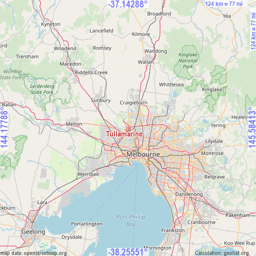
Tullamarine GPS coordinates[2]
37° 42' 4.608" South, 144° 52' 51.6" East
| Map corner | latitude | longitude |
|---|---|---|
| Upper-left | -37.14288°, | 144.17788° |
| Center: | -37.70128°, | 144.881° |
| Lower-right: | -38.25551°, | 145.58413° |
| Map W x H: | 123.7×123.7 km | = 76.9×76.9mi |
| max Lat: | -10.58257° ⇑84.9% North |
| Tullamarine: | -37.70128° |
| min Lat: | ⇓15.1% South -43.31423° |
| min Long | Tullamarine | max Long |
| 113.53327° | 144.881° | 153.61246° |
| W 31.8%⇐ | ⇒68.2% E |
Elevation
Elevation of Tullamarine is 96 m = 315 ft, and this is 26 m = 85 ft below average elevation for this country.
| Max E: |
1715 m = 5627 ft | 31% |
| Avg. | 122 m = 400 ft | |
| Tullamarine | 96 m = 315 ft | |
Min E: |
-2 m = -7 ft | 69% |
See also: Australia elevation on elevation.city.
Geographical zone
Tullamarine is located in South temperate zone (between Tropic of Capricorn and the Antarctic Circle). Distance of this Southern Tropic circle is 1586.1 km =985.6 mi to North.| Distance of | km | miles | from Tullamarine |
|---|---|---|---|
| Equator | 4192 | 2604.8 | to North |
| Tropic Capricorn | 1586.1 | 985.6 | to North |
| Antarctic Circle | 3209.2 | 1994.1 | to South |
| South Pole | 5815.1 | 3613.3 | to South |


Nearby cities:
15 places around Tullamarine: (largest is in red/bold)
• Airport West
2.6 km =1.6 mi,  179°
179°
• Attwood
3.6 km =2.2 mi,  8°
8°
• Broadmeadows
4.1 km =2.5 mi,  54°
54°
• Gladstone Park
1.6 km =1 mi,  18°
18°
• Glenroy
4.6 km =2.9 mi,  88°
88°
• Gowanbrae
1.2 km =0.7 mi,  131°
131°
• Jacana
3 km =1.9 mi,  60°
60°
• Keilor
4.5 km =2.8 mi,  247°
247°
• Keilor East
3.8 km =2.4 mi,  201°
201°
• Keilor Park
3.2 km =2 mi,  228°
228°
• Melbourne Airport
4 km =2.5 mi,  319°
319°
• Niddrie
4.1 km =2.5 mi,  166°
166°
• Oak Park
3.9 km =2.4 mi,  119°
119°
• Strathmore Heights
1.9 km =1.2 mi, 133°
• Westmeadows
2.9 km =1.8 mi, 10°
Sources, notices
• [Note1] Compared only with cities in Australia existing in our database
• [Src1] Map data: © OpenStreetMap contributors (CC-BY-SA)
• [Src2] Other city data from geonames.org with taken over terms of usage.
• [Src3] Geographical zone / Annual Mean Temperature by Robert A. Rohde @ Wikipedia
