Coolaroo geodata
Coolaroo (Victoria) is a section of populated place; located in Australia in Australia/Melbourne (GMT+11) time zone. With population of 3,181 people, there are 2140 cities with bigger population in this country. Compared to other cities in Australia, 84% of cities are located further ↑North; 67.5% of cities are located further →East and 77% of cities have lower elevation than Coolaroo. Note1


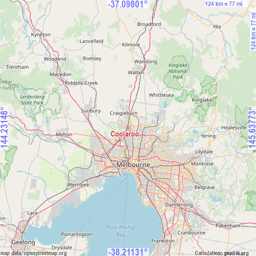
Coolaroo GPS coordinates[2]
37° 39' 24.3" South, 144° 56' 4.56" East
| Map corner | latitude | longitude |
|---|---|---|
| Upper-left | -37.09801°, | 144.23148° |
| Center: | -37.65675°, | 144.9346° |
| Lower-right: | -38.21131°, | 145.63773° |
| Map W x H: | 123.8×123.8 km | = 76.9×76.9mi |
| max Lat: | -10.58257° ⇑84% North |
| Coolaroo: | -37.65675° |
| min Lat: | ⇓16% South -43.31423° |
| min Long | Coolaroo | max Long |
| 113.53327° | 144.9346° | 153.61246° |
| W 32.5%⇐ | ⇒67.5% E |
Elevation
Elevation of Coolaroo is 148 m = 486 ft, and this is 26 m = 85 ft above average elevation for this country.
| Max E: |
1715 m = 5627 ft | 23% |
| Coolaroo | 148 m 486 ft | |
| Avg. | 122 m = 400 ft | |
Min E: |
-2 m = -7 ft | 77% |
See also: Australia elevation on elevation.city.
Geographical zone
Coolaroo is located in South temperate zone (between Tropic of Capricorn and the Antarctic Circle). Distance of this Southern Tropic circle is 1581.1 km =982.4 mi to North.| Distance of | km | miles | from Coolaroo |
|---|---|---|---|
| Equator | 4187 | 2601.7 | to North |
| Tropic Capricorn | 1581.1 | 982.4 | to North |
| Antarctic Circle | 3214.1 | 1997.1 | to South |
| South Pole | 5820 | 3616.4 | to South |


Nearby cities:
15 places around Coolaroo: (largest is in red/bold)
• Attwood
4.4 km =2.7 mi,  251°
251°
• Broadmeadows
3 km =1.9 mi,  208°
208°
• Campbellfield
2.3 km =1.4 mi,  109°
109°
• Craigieburn
6.5 km =4 mi,  12°
12°
• Dallas
1.6 km =1 mi,  177°
177°
• Gladstone Park
5.4 km =3.4 mi,  231°
231°
• Glenroy
4.8 km =3 mi, 181°
• Gowanbrae
6.9 km =4.3 mi, 213°
• Greenvale
6.5 km =4 mi,  293°
293°
• Hadfield
5.7 km =3.5 mi,  173°
173°
• Jacana
4 km =2.5 mi, 210°
• Meadow Heights
1.5 km =0.9 mi, 293°
• Roxburgh Park
3.5 km =2.2 mi,  346°
346°
• Tullamarine
6.8 km =4.2 mi,  223°
223°
• Westmeadows
4.7 km =2.9 mi,  242°
242°
Sources, notices
• [Note1] Compared only with cities in Australia existing in our database
• [Src1] Map data: © OpenStreetMap contributors (CC-BY-SA)
• [Src2] Other city data from geonames.org with taken over terms of usage.
• [Src3] Geographical zone / Annual Mean Temperature by Robert A. Rohde @ Wikipedia
